D1 · Publication Volume 17
Data Preparation and Domain Concepts
valid data, coding, contacts, domains and hierarchy
Learning objectives
By the end of this lesson, the learner should be able to build a model-input register; validate coordinates, intervals, categories and structural measurements; convert observations into derived constraints without losing the original records; define domain concepts and hierarchy before drawing boundaries; and document exclusions, conflicts and transformations as part of model evidence.
Preparation is not clerical cleaning. It determines which observations enter the interpretation, how they are weighted and which geological relations the construction method can see. A beautifully interpolated surface built from misregistered contacts or ambiguous codes is a precise representation of a preparation failure.
Source register and evidence classes
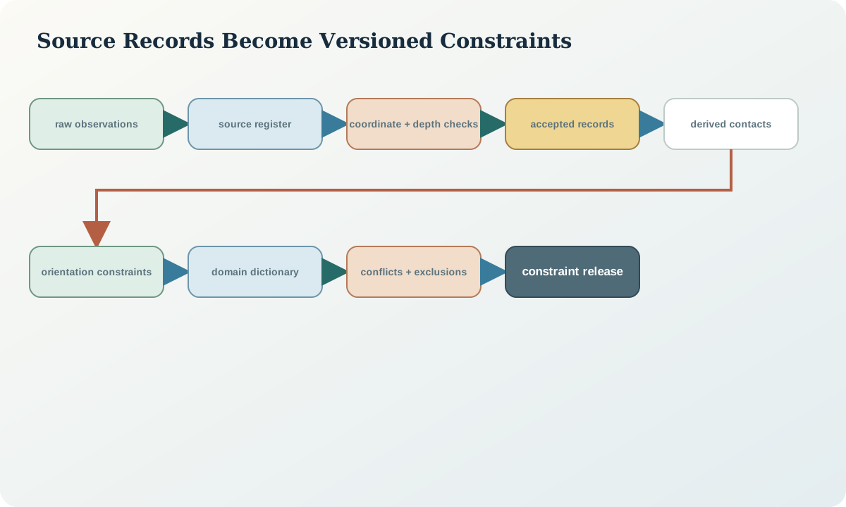
Create one register row for every source collection or derived dataset. Record identifier, version, spatial and temporal extent, coordinate reference, units, observation support, collection method, quality state, licence or access boundary, transformation history and intended model role. Preserve raw, accepted and derived states separately.
Classify evidence by what it constrains. Contact points constrain a boundary location. Orientations constrain local geometry. Drillhole intervals constrain membership along a path. Map polygons constrain surface expression but may embed interpretation. Geophysical inversions constrain a physical-property response rather than lithology directly. Cross-sections contain interpreted geometry and should not be treated as independent observations unless their underlying evidence is separated.
Coordinate, depth and interval validation
Confirm horizontal reference system, vertical datum, axis order, units and sign conventions before spatial combination. For drillholes, validate collar, trajectory, measured depth and interval rules before extracting contacts. A contact at measured depth is not a 3D point until the adopted trajectory and conventions have transformed it. Preserve the source depth and trajectory version used to derive the point.
Test interval tables for start less than end, non-negative depths, gaps, overlaps, duplicate boundaries and depth beyond the adopted hole length. Distinguish “not logged,” “no intersection,” “outside model,” “unknown” and “not applicable.” Collapsing those states to one null can create false absence constraints.
Contact and orientation constraints
A contact constraint needs position, boundary identity, side or younging relation where known, source and positional tolerance. Multiple records at the same nominal contact may disagree because of logging resolution, recovery loss, trajectory revision or geological complexity. Do not average them automatically. Investigate whether they represent one uncertain boundary, several strands or a coding mismatch.
Orientations require reference frame, measurement type, polarity, confidence and support. A point orientation inferred from a long interval is not equivalent to a direct planar measurement. Derived poles, gradients and direction vectors must link to the original measurement and transformation. When polarity is unknown, preserve an axial rather than directed constraint if the method permits it.
Codes, vocabularies and domain hierarchy
Define controlled identifiers separately from display labels. A domain concept should state its geological meaning, inclusion criteria, exclusions, parent, permitted children and relationship to neighbouring domains. Hierarchy can distinguish stratigraphic group, formation, member, alteration domain and mineralisation domain without forcing them into one flat code list.
Do not use a domain code merely because it is convenient for interpolation. Ask whether the included material shares the continuity, chronology or response assumed by the next method. A code can be valid for mapping and invalid for property estimation. Preserve crosswalks when categories are regrouped; never overwrite the source log to match the model legend.
Conflict resolution and quality states
Conflicts are evidence, not clutter. Record whether a conflict was resolved by source priority, re-logging, spatial review, revised trajectory, revised stratigraphy or a new scenario. If it remains unresolved, carry it as an alternative or uncertainty zone. A priority rule should be geological and quality-based, not simply “newest wins.”
Assign quality states such as accepted, accepted-with-limitation, excluded and unresolved. Every exclusion needs a reason and scope. Keep excluded data visible to reviewers; otherwise a model can appear to honour all evidence because contradictory observations disappeared during preparation.
Synthetic worked example
In the fictional volume, three logs use codes U3, Unit-C and felsic marker for what may be the same horizon. Two holes were resurveyed, shifting their deeper contact points by 18–27\,\mathrm{m}. One interval table overlaps by 0.6\,\mathrm{m}, and a surface polygon was digitised from a map whose scale is coarser than the planned model output.
Preparation creates immutable source records, a versioned code crosswalk and derived contact points tied to the revised trajectories. The overlapping interval is quarantined pending review. The map-derived contact receives a wider positional tolerance and is not duplicated as both a polygon edge and a set of “independent” points. The uncertain code correlation remains a scenario variable rather than being forced into one interpretation.
Practice and review checklist
Build a preparation report for a small mixed dataset. Include a source register, coordinate checks, interval tests, category frequencies, contact extraction logic, orientation transformations, conflict list and exclusion table. Review these questions:
- Can every derived 3D constraint be traced to a source record and transformation version?
- Are map interpretations distinguished from direct observations?
- Do null and absence states retain different meanings?
- Does each domain have geological membership rules rather than only a colour?
- Are conflicting observations visible after preparation?
- Would changing a trajectory or code crosswalk invalidate cached constraints?
Decision record and integration
Release a constraint package with stable identifiers, not an anonymous collection of points. Each constraint should carry type, object identity, value, tolerance or confidence, source, transformation and status. The domain dictionary and relationship hypotheses should accompany it.
The next modelling stages must consume the accepted package by version. If a constraint changes, record which surfaces, solids and validations depend on it. This turns preparation into the first node of model lineage rather than an undocumented pre-processing step.
Sources
- GeoSciML 4.1, models geological features, borehole intervals, observations and controlled semantics.
- PROV-O, provides concepts for source entities, transformations and derived records.
- An inventory of three-dimensional geologic models, illustrates model-source and attribute registers for published models.
- Automated stratigraphic interpretation with uncertainty quantification, demonstrates how alternative stratigraphic solutions can be retained and compared.