A2 · Publication Volume 3
Evidence for Plate Motion
seafloor spreading, palaeomagnetism, earthquake distribution, GPS and plate boundaries
Learning objectives
After this lesson, you should be able to explain how independent evidence supports plate motion, distinguish present velocity from long-term reconstruction, interpret magnetic-anomaly symmetry, and recognise where a rigid-plate model becomes an approximation.
A theory built by convergence
Plate tectonics succeeded because it explained observations that had previously belonged to separate problems: the fit and geological continuity of continents, seafloor topography, oceanic heat flow, magnetic reversals, earthquake belts, volcanic arcs, deep-sea trenches and young ocean-floor ages. Modern space geodesy directly measures relative motion. No one observation carries the entire theory; their mutual consistency is the strength.
A tectonic plate is a region of lithosphere that can be approximated as rotating about an Euler pole relative to another plate. On a sphere, relative velocity varies with position even when the plate is internally rigid. Real plates contain deformation, and continental boundaries may be hundreds or thousands of kilometres wide. A plate map is a model whose resolution must fit the question.
Seafloor spreading and ocean-floor age
Mid-ocean ridges form a connected system where mantle upwelling, decompression melting and crustal accretion produce new oceanic lithosphere. As lithosphere moves away, it cools, thickens and commonly subsides. Ocean-floor age generally increases away from ridge axes and terminates at subduction zones or continental margins. The scarcity of very old oceanic lithosphere compared with continental crust is expected if oceanic lithosphere is continually created and recycled.
Bathymetry alone does not give a spreading rate. Age control from magnetic anomalies, radiometric dating and drilling provides the time axis. If two reliably correlated anomaly picks are distance d apart along a flow line and differ in age by \Delta t, the average half-spreading rate is approximately d/\Delta t for one flank. Full spreading rate compares separation of both plates. Oblique measurement or ridge jumps can invalidate the simple calculation.
Magnetic stripes as a recording system
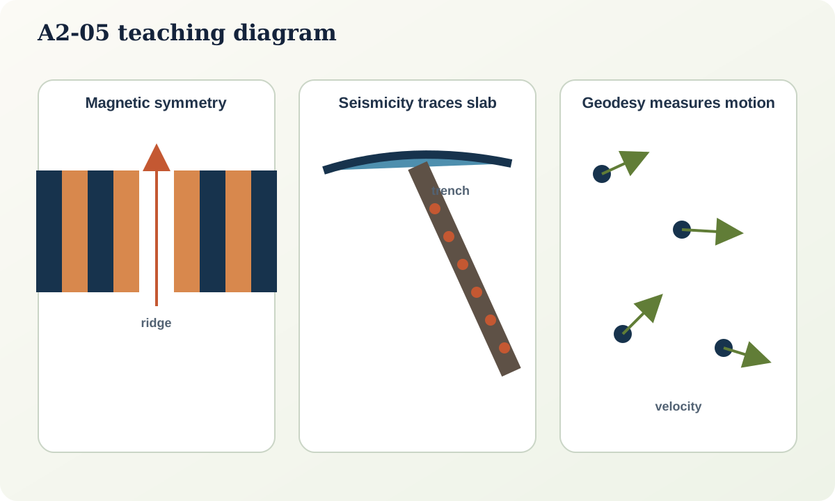
Basalt cooling through magnetic blocking temperatures can acquire remanent magnetisation aligned with the ambient geomagnetic field. Earth's magnetic polarity has reversed many times. Seafloor spreading therefore creates bands of normal and reversed polarity that are approximately symmetric about a stable ridge segment.
The observable is a magnetic anomaly produced by the contrast between magnetised crust and a reference field. Interpretation requires navigation, reduction of the main field, anomaly correlation and a geomagnetic polarity timescale. Symmetry may be interrupted by ridge propagation, asymmetric spreading, faulting, sediment cover or later alteration. The pattern is compelling because its sequence predicts independently dated reversal order.
Earthquakes and Wadati–Benioff zones
Global earthquake epicentres cluster along ridges, transforms, subduction zones and broad continental deformation belts. At a subduction zone, earthquake hypocentres may define an inclined zone extending from shallow depths into the mantle. This geometry traces a cold descending slab far more directly than a surface trench alone.
Depth and focal mechanisms matter. Ridges and most transforms are dominated by shallow earthquakes; subduction produces shallow interface events, intraslab events and sometimes intermediate or deep seismicity. Earthquake absence is not proof of no deformation: ductile strain, slow slip or incomplete detection may carry motion.
Volcanoes, trenches and topography
Volcanic arcs commonly lie above subducting slabs but not directly at the trench. Water and other volatiles released from the slab promote melting in the mantle wedge; buoyant magma ascends through the overriding plate. The arc–trench system, forearc, backarc and earthquake geometry form a coherent set. At divergent boundaries, volcanism follows decompression melting. Intraplate volcanic chains may record plate motion over a relatively fixed melting anomaly, but plume motion, lithospheric structure and multiple melting mechanisms complicate the track.
Geodesy measures current motion
GNSS, very-long-baseline interferometry, satellite laser ranging and related methods estimate positions within a terrestrial reference frame. Repeated measurements yield velocities, often at millimetre-per-year precision under suitable conditions. Public space-geodesy systems and open observation archives provide data used for crustal-motion and plate studies.
Geodetic velocity is not automatically plate velocity. Stations can move because of elastic strain near a locked fault, earthquakes, volcanic deformation, groundwater or ice loading, monument instability and reference-frame effects. A plate-motion estimate selects stable interior stations, models transient signals and reports covariance. Short records may not represent long-term rates.
Palaeomagnetism and continental reconstruction
Remanent magnetisation in rocks can constrain past latitude and rotation relative to the geomagnetic field. Apparent polar-wander paths from different continents become mutually consistent when continental motions are allowed. Palaeomagnetism generally does not determine palaeolongitude, and remagnetisation can overwrite the primary signal. Geological piercing points, fossil provinces, stratigraphic belts, orogenic histories and seafloor anomalies provide additional constraints.
Worked example: testing a spreading interpretation
Across an ocean ridge, a survey finds parallel magnetic anomalies, high heat flow at the axis, shallow normal-fault earthquakes and seafloor ages that increase outward.
- Map anomalies on both flanks and test sequence symmetry rather than relying on one stripe.
- Use dated polarity boundaries to calculate rates along flow-normal profiles.
- Check whether offsets coincide with transform faults and whether earthquake mechanisms match transform sense.
- Compare predicted relative motion with geodetic or global plate models.
- Report rate changes and ridge jumps rather than forcing one constant rate.
Each observation has alternative local explanations; together they strongly constrain seafloor spreading.
Practical investigation
Take three station velocities from a published GNSS solution. Plot them with uncertainty ellipses in both a global frame and a plate-fixed frame if available. Identify common motion, internal deformation and any station whose behaviour may be non-tectonic. Then compare the geodetic interval with the million-year interval sampled by marine anomalies.
Mastery check
- Why is symmetric anomaly sequence more informative than a single magnetic high?
- What information does an inclined earthquake zone provide at a subduction margin?
- Give four reasons why a GNSS station may not represent rigid-plate motion.
- Why do palaeomagnetic reconstructions usually constrain latitude more strongly than longitude?
Sources and further reading
- Understanding Plate Motions, U.S. Geological Survey.
- Earthquakes and Plate Tectonics, U.S. Geological Survey.
- Solid Earth data access and tools, NASA Earthdata.
- LAGEOS mission, NASA Science.