A2 · Publication Volume 3
Basins, Orogens and Intraplate Deformation
basin subsidence, orogeny and deformation within plates
Learning objectives
After this lesson, you should be able to explain accommodation and subsidence, compare major tectonic basin mechanisms, relate basin fill to adjacent orogens, and recognise how inherited structures and far-field stress deform plate interiors.
A basin is more than a low place
A sedimentary basin is a region that acquires and preserves sediment because accommodation is created relative to a depositional reference level. Present topography may not reveal its original geometry: a basin can be inverted, uplifted, eroded or buried beneath younger cover. Basin analysis combines stratigraphy, thickness, facies, palaeocurrent, structure, subsidence history and geophysics.
Total subsidence is not observed directly at one outcrop. Backstripping progressively removes sediment and water loads, with assumptions about compaction, palaeobathymetry, sea level and density, to estimate tectonic subsidence. Each assumption has uncertainty. A smooth curve can conceal unconformities and spatially variable fault motion.
Mechanisms that create accommodation
Common first-order mechanisms include:
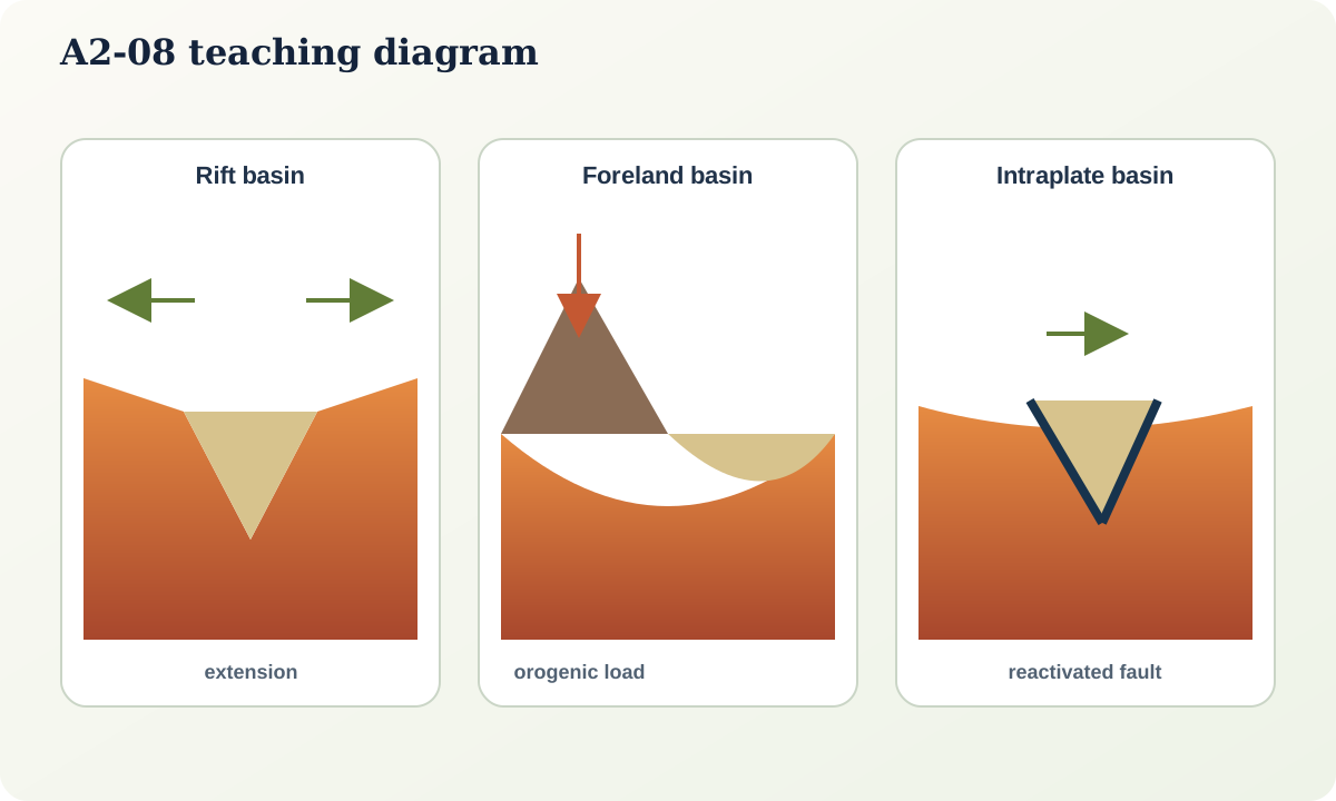
- lithospheric stretching: normal faulting produces syn-rift accommodation; later thermal cooling drives broader post-rift subsidence;
- flexure: a load such as an orogen or volcanic edifice bends the lithosphere, producing a foreland or peripheral basin and a flexural bulge;
- dynamic topography: mantle flow exerts stresses that raise or lower the surface over broad wavelengths;
- strike-slip kinematics: releasing stepovers can form pull-apart basins, while restraining bends uplift and shorten crust;
- thermal or magmatic processes: heating, cooling, intrusion or underplating changes density and thickness; and
- dissolution, compaction and fluid withdrawal: important at more local scales but not interchangeable with plate-scale subsidence.
Observed geometry may result from several mechanisms in sequence. A rift basin can later become a foreland basin and then be inverted.
Rift and passive-margin basins
Syn-rift strata commonly thicken toward active normal faults and contain growth structures. Sediment source and facies shift as fault blocks rotate and catchments reorganise. If breakup occurs, marine spreading separates conjugate margins. Post-rift cooling and sediment loading produce a broader sag. Salt or overpressured shale can later decouple deformation, creating structures unrelated to the original basement-fault geometry.
Restoring a rift requires more than reversing visible faults. Compaction, erosion, fault linkage, out-of-plane displacement and depth conversion affect the result. Seismic reflection images acoustic interfaces; interpretation from time to depth needs a velocity model.
Foreland basins and orogenic sediment routing
Thrust loading can flex the adjacent plate to form a foredeep. Erosion of the rising orogen supplies sediment; provenance and palaeocurrents track source evolution. The basin may migrate as the load and thrust front move. A wedge-top zone, foredeep, forebulge and back-bulge may be distinguished in idealised models, but real geometries respond to lithospheric strength, inherited structure and sediment supply.
The preserved sediment is not a direct erosion gauge. Storage upstream, recycling of older basins, changing climate and along-strike transport all modify the signal. Detrital mineral ages and chemistry constrain source possibilities but remain affected by fertility and preservation bias.
Intraplate deformation
Plate interiors are less active on average than boundaries, not stress-free. Far-field plate forces, gravitational potential, mantle flow, sediment or ice loading and thermal effects can reactivate faults. Orientation and frictional strength matter: an inherited structure favourably oriented to the current stress may move while a new fracture does not form.
The same fault can experience multiple kinematic regimes. A normal fault may later invert in compression; a basement structure can localise folding in cover. To claim reactivation, demonstrate shared geometry and timing rather than merely overlapping lineaments.
Orogen–basin feedback
Mountain building creates relief and sediment; erosion removes mass and can influence isostatic rebound; sediment loading flexes basins; fluids and heat move through evolving structures. The orogen and basin are therefore one mass-transfer system. However, correlation is not immediate causation: climate can change erosion rate without a tectonic pulse, and dating a sediment population may not date fault slip.
Worked example: diagnosing basin phases
A seismic line shows half-grabens with Jurassic growth strata, a widespread Cretaceous sag, and Cenozoic reverse reactivation of some normal faults. Apatite thermochronology indicates later cooling, while an angular unconformity truncates folded strata.
The simplest phased model is Jurassic extension, post-rift thermal subsidence, then Cenozoic inversion and erosion. Yet timing must be bracketed: the thermochronological signal may reflect regional exhumation rather than motion on each fault; reverse faults may branch from, not perfectly reuse, normal faults. Cross-line control and depth conversion test three-dimensional geometry.
Practical investigation
Choose a public basin cross-section. Make separate panels for observation, restored geometry and causal interpretation. Colour only observed horizons in the first panel. In the second, state compaction and fault assumptions. In the third, rank at least two subsidence mechanisms and identify the measurement that would most change the ranking.
Mastery check
- Why is present-day topographic depression not a sufficient basin definition?
- What assumptions enter a tectonic-subsidence estimate?
- How can an orogen generate both load and sediment for a basin?
- What evidence is needed to distinguish fault reactivation from a new nearby fault?
Sources and further reading
- Australian Geological Provinces, Geoscience Australia.
- Phanerozoic evolution of sedimentary basins, U.S. Geological Survey.
- Geologic settings of subsidence, U.S. Geological Survey publication record.