A2 · Publication Volume 3
Australian and Queensland Geological Framework
stable continent, major terranes, basins and the broad distribution of mineral provinces
Learning objectives
After this lesson, you should be able to read a national province framework at its intended scale, describe Australia's broad crustal architecture, place Queensland within a long-lived eastern margin, and construct a global-to-local interpretation without treating province boundaries or metallogenic associations as proof.
Why use a regional framework?
The first nine lessons develop portable concepts. A regional framework tests whether they can be applied without collapsing scale. Australia contains ancient cratonic elements, Proterozoic provinces, Phanerozoic eastern belts, sedimentary basins and younger cover. Queensland crosses several of these elements and preserves evidence of accretion, magmatism, deformation, basin development and surface reworking.
This chapter is an orientation, not a substitute for current geological maps, stratigraphic databases or site investigation. Boundaries and names change as mapping, geochronology and geophysics improve. Always record dataset edition, scale and authority.
National crustal architecture
At continental scale, Australia's oldest crust is commonly organised around western, northern and southern cratonic elements and intervening Proterozoic mobile belts. Much of the eastern continent consists of younger Paleozoic to Mesozoic orogenic belts assembled and modified along the Gondwanan margin. Sedimentary basins of different ages overlie and obscure basement, while Cenozoic sediments, regolith and volcanic rocks further mask relationships.
This is deliberately broad. A crustal element may be inferred beneath cover from geophysics, isotopes and sparse basement intersections. A tectonic province groups rocks related by geological history; a sedimentary basin groups a subsiding region and its fill; an igneous or metallogenic province uses different criteria. Their boundaries need not coincide.
A public geological-provinces database may include sedimentary basins, tectonic provinces, igneous provinces, metallogenic provinces and crustal elements in the same collection. Its metadata may also warn that coverage is incomplete, descriptions have not undergone uniform quality assurance, or definitions remain contentious. Those qualifications are part of the data, not footnotes to ignore.
Queensland in the eastern Australian context
Queensland includes ancient to Proterozoic basement in the west and northwest, Paleozoic orogenic and magmatic provinces through central and eastern regions, and extensive Paleozoic–Mesozoic and younger basins and cover. At the broadest level, the eastern belts record prolonged addition, deformation and reworking near the former eastern Gondwanan margin. Later basin formation, intraplate volcanism, uplift, erosion and regolith development overprinted that framework.
The Queensland geological-framework dataset classifies structural or tectonic units as provinces and basins. In its published metadata, basins retain recognisable depositional form, whereas older strongly tectonised or metamorphosed basins may be classified as provinces. It also notes that intrusive and related volcanic rocks overlapping those units may be handled separately, and that subsurface basins depend on petroleum and geophysical interpretation. Therefore a framework polygon is not a complete inventory of all rocks at a point.
From province to local geology: a scale ladder
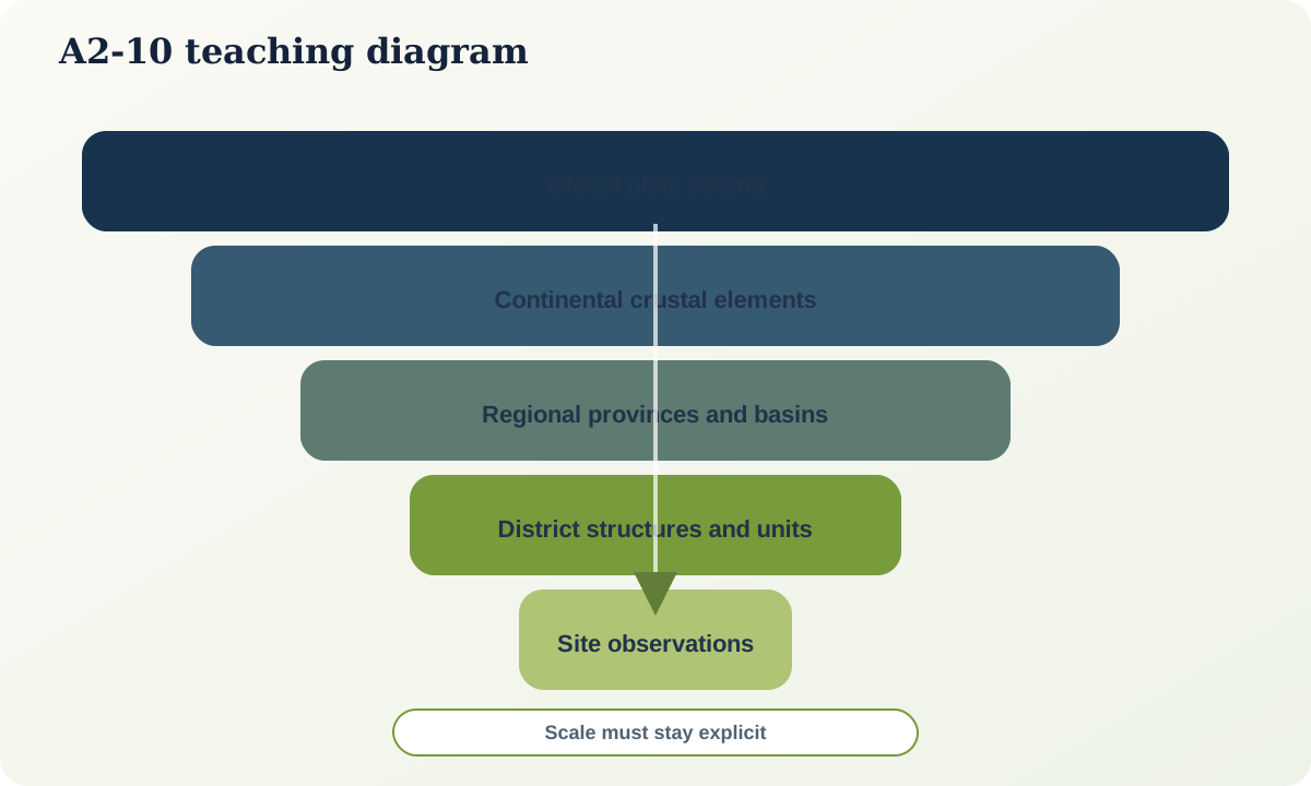
Use five linked scales:
- Global: plate configuration, latitude, ocean opening or closure, and major mantle or climate context.
- Continental: crustal elements, orogenic belts and continent-scale basins.
- Regional: named provinces, terranes, magmatic belts, structures and basin depocentres.
- District: stratigraphic groups, intrusive complexes, faults, alteration systems and cover architecture.
- Site or sample: observed lithology, texture, structure, mineral assemblage, age result and measurement uncertainty.
Evidence does not flow only downward. A well-dated local relationship may revise a regional boundary; a new geophysical image may change the inferred basement beneath a basin. Keep observations at their native scale and state the transformation used when comparing them.
Time–space stacks
A useful regional product is a time–space stack with columns for provinces or transects and rows for time intervals. Record deposition, magmatism, metamorphism, deformation, uplift and hiatus. The stack exposes impossible correlations and gaps. Use the current ICS chart for time units and the Australian Stratigraphic Units Database for formal Australian unit names and status.
Do not infer tectonic setting from age alone. Coeval rocks can form in different settings, and one province can contain several tectonic phases. Likewise, spatial association with a mineral province does not establish an ore-forming process or economic prospectivity. It is a prior context that generates questions.
Worked example: an evidence-led regional interpretation
Imagine a mapped district in eastern Queensland with deformed marine sedimentary rocks, several granitoid suites, a younger unconformable basin and patchy volcanic cover.
- Observe: compile mapped contacts, facing, structures, geochronology, geochemistry, geophysics and cover thickness with source and scale.
- Order: establish deposition, deformation, intrusion, erosion, basin filling and volcanism using cross-cutting relations and age brackets.
- Contextualise: test whether the older package belongs to a recognised orogenic province and whether magmatism is juvenile, reworked or mixed.
- Model alternatives: arc-related assembly, backarc development, accretionary deformation or later intraplate reactivation may explain subsets of evidence.
- Discriminate: identify the age, isotope transect, seismic profile or structural observation that would most reduce ambiguity.
The province label is used after evidence is assembled, not as a replacement for it.
Completion task: build the causal graph
For a nominated region, create at least four time slices and nodes for inherited crust, plate setting, sedimentation, magmatism, deformation, metamorphism, erosion, preservation and present observation. Every directed edge must contain:
- a mechanism stated as a verb phrase;
- direct and indirect supporting evidence;
- age or ordering constraint;
- confidence level and alternative; and
- the observation that would falsify or materially revise the link.
Add a scale tag to every node. Finish with a one-page audit separating what is observed, what is inferred from an authoritative regional framework, and what remains hypothetical.
Mastery check
- Why can tectonic, sedimentary, igneous and metallogenic province boundaries differ?
- What does a province polygon fail to tell you about a site?
- How can local evidence revise a continental framework?
- Why is association with a known mineral province not proof of a deposit-forming process?
Sources and further reading
- Australian Geological Provinces, Geoscience Australia.
- Continental Geology, Geoscience Australia.
- Australian Stratigraphic Units Database, Geoscience Australia.
- Queensland spatial-data links and geological-framework metadata, Queensland Government.
Closing synthesis
Plate tectonics is not a diagram of arrows on a globe. It is a tested framework that connects observations across scale and time while remaining open to revision in local detail. Deep-time reasoning does not merely attach dates to rocks; it orders events, identifies missing record and asks what each clock actually recorded. Earth-system thinking does not dissolve geology into an unlimited web; it defines reservoirs, fluxes, mechanisms and boundaries precisely enough to be tested.
The transferable habit is therefore simple to state and demanding to practise: begin with observations, build an ordered causal model, compare alternatives, preserve scale and uncertainty, and return to the evidence whenever the regional story feels too tidy.