D6 · Publication Volume 22
Biodiversity, Land and Rehabilitation
baseline, disturbance and rehabilitation criteria
Learning objectives
By the end of this lesson, the learner should be able to frame a defensible decision about baseline, disturbance and rehabilitation criteria; distinguish observation, interpretation, assumption, obligation and decision; construct a causal pathway with explicit spatial and temporal boundaries; use quantitative evidence without false precision; identify distributional and long-duration consequences; specify controls with triggers and accountable responses; and design a versioned evidence package that can be independently reviewed.
The objective is transferable reasoning, not memorisation of a jurisdiction, organisation or operating procedure. A learner must state where current law, rights, permits, engineering authority or specialist review governs a real decision. The tutorial supplies no universal threshold and authorises no field activity, disclosure, facility or closure outcome.
Decision context
The decision is how to avoid and manage change to biodiversity, ecological function and land while defining a credible rehabilitation trajectory. Start with ecological values, landscape connectivity, ecosystem services, land capability, rights and future use rather than a generic species list. Assessment scale must match the processes and populations that can be affected.
Write a decision contract before analysis. It should name the decision owner as a role rather than a person, affected systems, lifecycle phase, spatial and temporal support, applicable authority to be verified, evidence cut-off, alternatives, uncertainty, dependencies, irreversible choices and review trigger. Separate what the analysis can inform from what it cannot approve. If the boundary excludes a pathway or affected group, record the reason and the evidence needed to reconsider it.
Core concept: system and boundary
Biodiversity includes composition, structure, function and connectivity at genetic, species, habitat and landscape levels. Presence records are detection events conditioned by effort, season, weather and method. Habitat quality, population viability, movement, hydrology, fire, invasive organisms and cumulative fragmentation can matter more than the count from one survey.
Map the system as linked objects rather than a flat issue list. For every object, ask what state can change, which process causes the change, how quickly it propagates, what feedback exists and which observations could distinguish competing explanations. Keep physical, ecological, social, legal and governance relationships connected without pretending that one discipline can decide for another.
Core concept: pathways and obligations
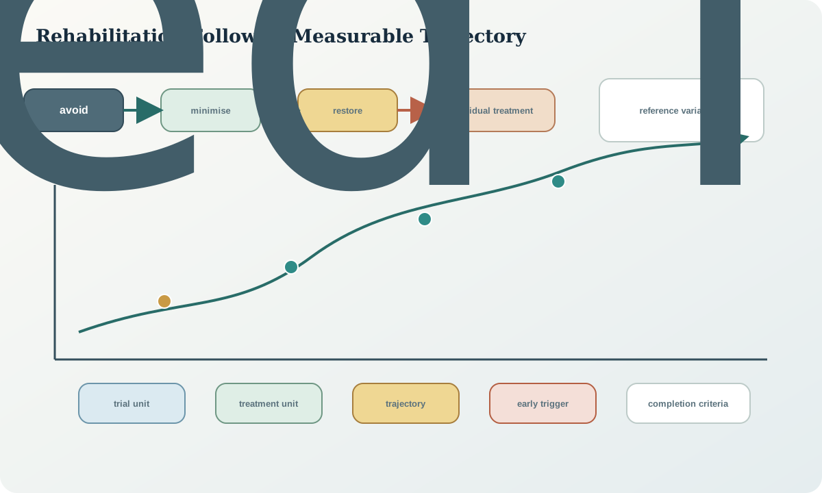
The mitigation sequence distinguishes avoidance, minimisation, restoration and treatment of residual effects. Rehabilitation is a managed trajectory toward agreed landform, soil, vegetation, habitat and use outcomes, not simply seeding disturbed ground. Reference conditions guide expectations but may require multiple analogues and adjustment for climate, legacy disturbance and desired post-mining use.
Obligations and controls also have a lifecycle. Record their origin, exact wording, intended outcome, affected interest, responsible role, dependencies, start condition, evidence, review point and release condition. Do not convert a conditional commitment into an unconditional claim, or a professional recommendation into an approved requirement. Where rights or consent apply, preserve the conditions and authority attached to them.
Quantitative reasoning
A transparent rehabilitation indicator reports components rather than hiding them in one score. For example, vegetation cover proportion, native richness, erosion density, soil stability and functional-group composition can each be compared with a declared reference distribution. If a composite S=sum_i w_i x_i is used, weights, scaling, covariance, uncertainty and failure rules must remain visible.
Before calculating, declare system boundary, support, units, time zone, reporting period, denominator, treatment of missing and censored data, uncertainty model and rounding. Compare raw, adjusted and modelled values rather than overwriting one with another. Sensitivity analysis should vary plausible drivers jointly where they are dependent. A neat number is not evidence that the underlying model is complete.
Evidence and uncertainty
Evidence includes survey design, effort, detection limits, vouchers or observation support, habitat mapping, remote observations, soil and seed resources, hydrology, disturbance history, rehabilitation trials, analogue variability and long-term trajectories. Separate no detection from confirmed absence. Protect sensitive locations and knowledge while retaining enough metadata for review.
Classify evidence as direct observation, laboratory result, derived value, model output, stakeholder or rights-holder input, requirement, expert judgement or assumption. Attach method, date, location or population support, quality state, access restriction and lineage. Confidence should explain both variability in the system and knowledge uncertainty. Conflicting evidence remains visible until a documented decision resolves or bounds it.
Lifecycle controls
Controls may redesign footprints, maintain buffers and corridors, time activities, manage light, noise, dust, water, weeds and fire, salvage soil or propagules, progressively rehabilitate, protect trial areas and trigger adaptive responses. Control effectiveness must be tested at the receptor scale. Offsetting a residual effect, where applicable, does not excuse weak avoidance evidence.
Use a control record with unwanted event, causal pathway, prevention or mitigation function, performance requirement, leading and lagging indicators, verification frequency, trigger, immediate response, escalation authority, recovery action and evidence of effectiveness. Controls must survive foreseeable change in climate, schedule, staff, contractors, data availability and lifecycle phase. A monitoring point without a response rule observes risk but does not control it.
Interfaces and data
Use versioned spatial objects for survey area, effort, observations, habitat, disturbance, rehabilitation unit, treatment, monitoring plot and reference site. Record taxonomy or concept version, method, observer role, date, access constraint and confidence. Generalised public geometry should never overwrite the restricted source location.
The minimum exchange contract specifies identifier, geometry or population support, coordinate and vertical reference where relevant, time basis, unit, vocabulary, null semantics, method, uncertainty, quality status, sensitivity, licence or use condition, version and checksum. Preserve raw evidence and make transformations reproducible. A dashboard, map or report is a view of controlled evidence; it must not become the only surviving record.
Integration checkpoint
The lesson checkpoint passes only when another reviewer can follow the chain from decision and affected interest through baseline, disturbance and rehabilitation criteria, evidence, uncertainty, alternatives, control and residual obligation. Every claimed control must have an observation that can test it, and every material observation must have a pre-agreed response path.
Ask four integration questions: What can change the conclusion? Who experiences the outcome and who has authority? Which lifecycle handover could lose the evidence or obligation? What remains after the proposed control succeeds? If any answer is hidden in narrative, convert it to a controlled record before advancing.
Synthetic worked example
A synthetic landform has 40 rehabilitation plots and 12 reference plots spanning three landscape positions. Median cover meets the provisional target, but lower-slope plots show concentrated erosion and low representation of deep-rooted functional groups. The learner rejects a site-wide pass based on the median, diagnoses the spatial mechanism and proposes a treatment trial with explicit success and stop rules.
The numbers and labels are synthetic and intentionally incomplete. Recalculate them from the stated basis, show any residual, and create at least two plausible explanations before selecting an action. Mark the evidence that would discriminate among explanations. Do not transplant the illustrative quantities, triggers or acceptance language to real work.
Practice task
Design a rehabilitation completion framework for a fictional disturbance. Include desired post-mining functions, reference strategy, measurable criteria, variability bands, monitoring frequency, spatial stratification, early warning indicators, corrective actions and evidence needed to relinquish each obligation. Explain how climate change affects the reference choice.
Submit the artefact with a one-page decision statement, data dictionary, assumptions register, alternative explanation, control table and change log. A peer should be able to locate every input and challenge every conditional step. The task is incomplete if it relies on an unnamed rule, a private conversation, an unexplained score or a figure that cannot be traced to versioned evidence.
Common failure modes
Common failures are equating biodiversity with a species count, surveying in one convenient season, mapping sensitive records at unrestricted precision, applying the mitigation sequence after footprint selection, setting criteria without reference variability, averaging failed landform units into a passing site result, and declaring completion before processes are demonstrably self-sustaining.
A cross-cutting failure is institutional storytelling: wording that implies a named organisation, person or website owns, endorses or supplies the tutorial or its conclusions. Another is site mimicry, where an invented example looks like a real property and borrowed parameters appear authoritative. Keep examples explicitly synthetic, roles anonymous, external names in source notes only and every real application dependent on current local evidence and authority.
Lesson summary
Biodiversity and rehabilitation decisions require process-aware baselines, avoidance-first design, protected knowledge, spatially stratified evidence and measurable trajectories toward agreed future functions. A green appearance alone does not demonstrate ecological or landform performance.
The durable output is not a final-looking score. It is a reviewable chain connecting purpose, affected systems, evidence, uncertainty, alternatives, decisions, controls, responsibilities and remaining obligations. That chain must be capable of change without erasing the earlier state.
Review questions
- What boundary and decision contract are required for baseline, disturbance and rehabilitation criteria?
- Which observations would distinguish the two most plausible causal explanations?
- Which quantities can be conserved or reconciled, and which judgements cannot be reduced to a score?
- How can a missing observation differ from a confirmed absence or zero?
- Which control has the earliest useful trigger and what action follows it?
- What evidence and obligation must survive the next lifecycle handover?
- How would you communicate the residual consequence without implying approval or certainty?
Sources
- Performance Standard 6: Biodiversity Conservation and Sustainable Management of Living Natural Resources, public source used to identify current concepts and review questions; applicability must be checked for the actual decision.
- Performance Standards on Environmental and Social Sustainability, 2012, public source used to identify current concepts and review questions; applicability must be checked for the actual decision.
- Kunming-Montreal Global Biodiversity Framework, public source used to identify current concepts and review questions; applicability must be checked for the actual decision.
- Environmental, Health and Safety Guidelines for Mining, public source used to identify current concepts and review questions; applicability must be checked for the actual decision.