E1 · Publication Volume 23
Latitude, Longitude and Datums
geographic coordinates, datum realisation and reference epochs
Learning objectives
interpret latitude and longitude as coordinates in a defined geodetic CRS; distinguish reference system, datum realisation, frame and coordinate epoch; convert conceptually between geodetic and geocentric coordinates; and test whether two similar tuples can be compared.
The objective is transferable reasoning, not operation of a named product or performance of regulated survey work. Every real decision must use current applicable requirements, authorised control and competent review.
Decision context
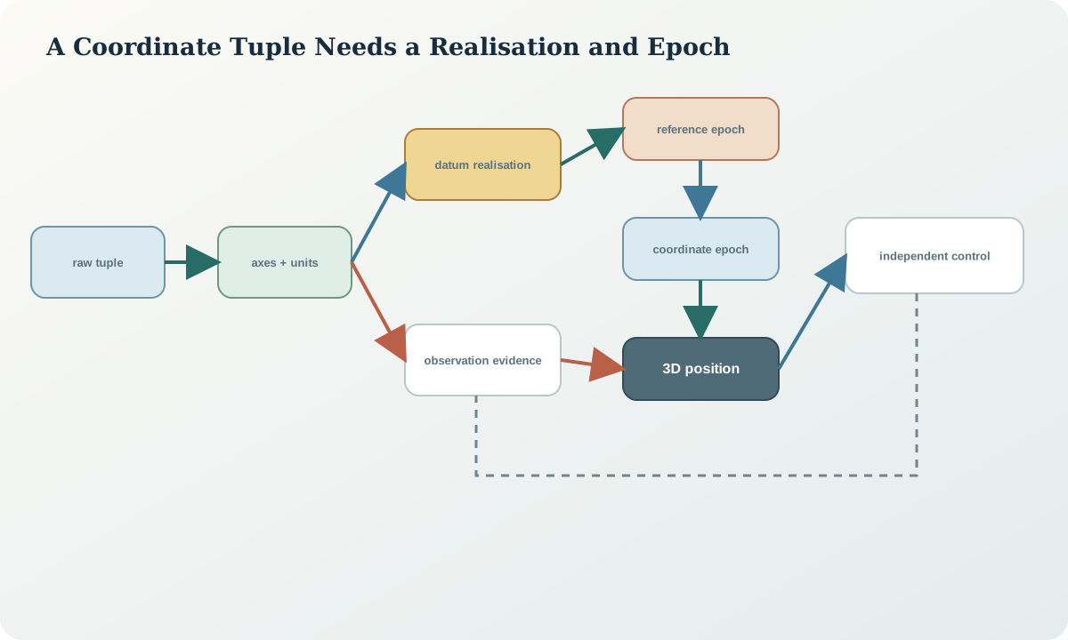
The decision is whether two geographic coordinate tuples describe the same physical point in compatible reference frames and at compatible epochs. Latitude and longitude are not self-identifying. The analyst must determine angular units, axis order, longitude range, ellipsoid, datum realisation, dimensionality, reference epoch, coordinate epoch, observation time and stated accuracy before measuring a difference.
A reference system defines concepts and conventions; a realisation connects those conventions to observations and control. A static or plate-fixed datum can hold coordinates constant within its intended region, while an Earth-fixed dynamic frame may require coordinates to vary with time. The words current, GPS and global are not precise datum definitions.
Core concept
Geodetic latitude \phi is the angle between the ellipsoid normal and equatorial plane; longitude \lambda is measured around the ellipsoid from the prime meridian. Geocentric latitude uses a line from the centre and is generally different. Latitude must lie in its valid interval, while longitude may use signed or wrapped conventions that must be normalised deliberately.
A datum realisation provides origin, orientation, scale and their relation to the Earth through a control network and reference epoch. Coordinates derived from a dynamic frame also need a coordinate epoch. The observation date tells when a measurement was made; it does not automatically state the epoch to which processing propagated the coordinate.
Reference frames and metadata
Metadata should record geodetic CRS identifier and full definition, ellipsoid, datum or reference-frame realisation, reference epoch, coordinate epoch, observation time, axis order, angular unit, dimensionality, height type, control source, processing method, velocity or deformation model where used, accuracy and area of use. Preserve the original textual definition because an informal name can refer to several realisations.
A geographic 2D CRS does not define ellipsoidal height merely because a file contains a third ordinate. A geographic 3D CRS does not define a gravity-related height. Compound horizontal and vertical definitions may be needed. When an epoch is absent, mark it unknown; do not substitute file creation time.
Quantitative reasoning
Geodetic coordinates can be mapped to Earth-centred Cartesian coordinates with X=(\nu+h)\cos\phi\cos\lambda, Y=(\nu+h)\cos\phi\sin\lambda and Z=[(1-e^2)\nu+h]\sin\phi, where \nu=a/\sqrt{1-e^2\sin^2\phi}. These equations expose why ellipsoid, angular unit and height type matter.
For a simple velocity illustration, a coordinate component at epoch t may be written x(t)=x(t_0)+v_x(t-t_0). Real frame transformations can include translations, rotations, scale, parameter rates and deformation models. Never apply the scalar illustration as a substitute for an authorised operation.
Evidence and uncertainty
Evidence includes receiver or survey processing reports, control-station coordinates and epochs, adjustment files, frame definition, antenna and orbit products, point velocity or deformation model, original headers and independent control. A copied latitude and longitude without processing lineage cannot establish which realisation was used.
Uncertainty is multidimensional and can be correlated. Angular uncertainty translates to different ground distance with latitude and direction. Frame uncertainty, control stability, time propagation and local deformation may dominate instrument repeatability. Report the covariance or error ellipse when available rather than collapsing it into unsupported decimal places.
Transformation and control
The control workflow parses the source tuple without changing it, normalises only under an explicit convention, resolves the CRS and epoch hypothesis, converts to a common three-dimensional frame using an authorised operation, applies time propagation where required, then compares coordinates and independent control. Source, intermediate and target values remain separate.
Stop when a coordinate lacks a defensible datum, a dynamic coordinate lacks an epoch, the point lies outside the operation area, the height dimension is incompatible or control residuals show a systematic pattern. A forced nearest-CRS choice is a hypothesis to test, never an accepted repair.
Interfaces and data
The data contract separates latitude, longitude, ellipsoidal_height, axis_order, angular_unit, geodetic_crs, datum_realisation, reference_epoch, coordinate_epoch, observation_time, transformation_operation, velocity_model, covariance and accuracy_class. A JSON object with keys lat and lon is still incomplete if the datum and epoch are absent.
APIs and tabular files often reverse longitude and latitude conventions. Validate both field names and declared CRS axes. Preserve negative signs, hemispheres and original string precision. Parsing degrees-minutes-seconds requires a documented rule for sign and hemisphere conflicts.
Integration checkpoint
The checkpoint passes when the learner can explain why identical latitude and longitude values may refer to different physical positions, and why different values may describe the same position after a frame and epoch change. The transformation path must be reproducible and the rejected datum hypotheses visible.
Independent control should test position, not merely format. Range checks can detect impossible latitude, but cannot distinguish two plausible datums. A map background can reveal a gross swap, but cannot validate metre- or centimetre-level alignment.
Synthetic worked example
Two synthetic records both show latitude -31.250000 degrees and longitude 121.750000 degrees. Record A has a complete static-datum definition and epoch convention; Record B contains only a filename suggesting a later system. The learner does not subtract the tuples. Instead, B is treated as three hypotheses: correctly labelled later datum, copied coordinates in the earlier datum, or global-frame observation at an unknown epoch.
Independent control and processing metadata distinguish the hypotheses. A displacement pattern that is coherent across points supports a frame mismatch; scattered residuals suggest other errors. The coordinates and patterns are synthetic and identify no real place.
Practice task
Audit a synthetic table containing decimal degrees, degrees-minutes-seconds, radians, swapped axes, longitudes in two ranges and one dynamic coordinate without an epoch. Produce a non-destructive normalisation table, identify which records can be transformed and design evidence requests for the remainder.
Submit the original strings, parsed numeric values, axis and unit decisions, CRS hypotheses, epoch register, transformation graph and independent validation plan.
Common failure modes
The following failures are treated as evidence or process defects, not cosmetic issues:
- assuming latitude-longitude means one universal CRS.
- confusing observation date with coordinate epoch.
- assigning a height to a 2D geographic CRS.
- silently wrapping longitude or swapping axes.
- treating filename text as datum evidence.
- ignoring frame rates or local deformation.
- comparing angular decimal places as linear accuracy.
For each failure, preserve the original evidence, identify its downstream reach, define a discriminating test and record whether the case is corrected, rejected or still unresolved.
Review questions
- How does a datum realisation connect coordinates to the physical Earth?
- What is the difference between reference epoch, coordinate epoch and observation time?
- Why is a third ordinate not automatically ellipsoidal height?
- Which evidence can distinguish two plausible datum hypotheses?
- Why must angular uncertainty be interpreted spatially?
Answer with definitions, evidence, a calculation or test where relevant, and the condition that would reverse the conclusion. A product screenshot or unexplained code is not an answer.
Assessment artefact
The assessment artefact is a datum, frame and epoch register with a coordinate-hypothesis test. It records raw tuples, parsing rules, CRS definitions, dimensionality, time metadata, candidate operations, controls, residual vectors, selected interpretation and unresolved records. It must show that no coordinate was moved merely to make a map look right.
Sources and further reading
- GDA2020 Technical Manual, version 1.8, official technical definitions, formulae and worked computations; confirm the current version before operational use.
- The Australian Geospatial Reference System, official overview of datums, reference frames, working surfaces and infrastructure.
- Geocentric Datum of Australia 2020, official background on the datum realisation, reference epoch and relationship to modern positioning.
- Time-dependent Position Vector transformation, authoritative registry entry illustrating epoch-dependent transformation parameters.