E1 · Publication Volume 23
MGA in the Australian Context
GDA, MGA zones, datum changes and project implications
Learning objectives
relate GDA94 and GDA2020 to their MGA projected counterparts; identify Australian zone, datum generation and epoch implications; choose between conformal and distortion-aware transformation evidence; and design a migration that preserves legacy coordinates.
The objective is transferable reasoning, not operation of a named product or performance of regulated survey work. Every real decision must use current applicable requirements, authorised control and competent review.
Decision context
The decision is how to integrate Australian spatial data whose coordinate labels, control and accuracy span more than one datum generation. GDA94 and GDA2020 are distinct static datum realisations with different reference epochs and control. MGA94 and MGA2020 are projected systems built on those respective datums. A zone number without the datum generation is incomplete.
The commonly cited national-scale displacement between the datum generations is an orientation clue, not a universal correction vector. Regional distortion, control propagation, local movement, operation choice and data quality affect actual differences. Current legal, cadastral, survey and agency requirements must be checked for the real jurisdiction and decision.
Core concept
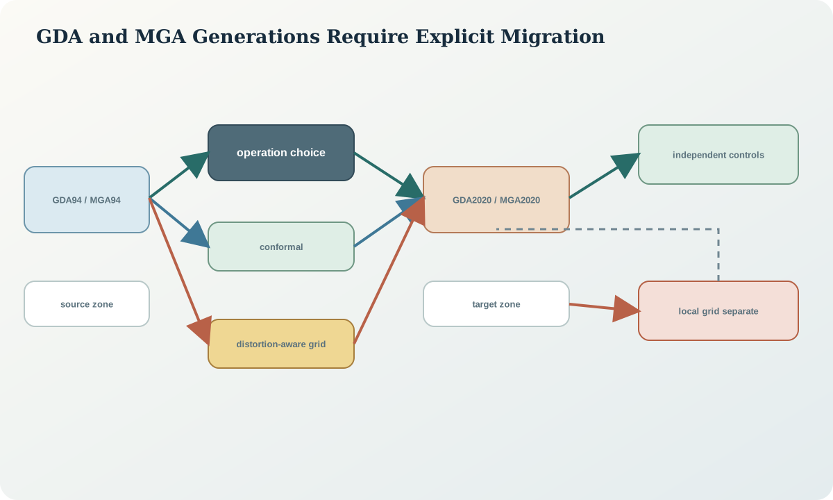
Geographic GDA coordinates use latitude and longitude; MGA coordinates use a transverse grid with zone, easting and northing. Much of Australia is represented in zones 49 through 56, but the applicable zone follows longitude and the authoritative CRS definition. MGA94 and MGA2020 numbers can be close enough to look plausible while differing enough to matter for survey, drilling, infrastructure and change detection.
A transformation between datum generations may use a similarity component or a grid that also models spatially varying distortion. The selected operation must match the source control, target use, area and accuracy need. If a local network was adjusted or held fixed under special constraints, an independent local calibration may still be required after the national operation.
Reference frames and metadata
The inventory records GDA generation, geographic or projected form, MGA zone, complete identifier, horizontal dimensionality, ellipsoidal-height treatment, coordinate epoch where present, control source, operation used, transformation-grid name and checksum, area of use, stated accuracy and project adoption status. Keep legacy coordinates in their original CRS as evidence.
Do not replace every mention of 94 with 2020 or edit identifiers in place. A coordinate migration creates a target dataset and a reconciliation table linking source and target feature identifiers. Maps and tables must make the datum generation visible wherever a coordinate is copied or exported.
Quantitative reasoning
For a longitude \lambda expressed in degrees, a common global zone rule is z=\lfloor(\lambda+180)/6\rfloor+1, subject to boundary and system conventions. The corresponding central-meridian pattern is \lambda_0=6z-183 degrees. These rules help detect a grossly wrong zone but do not validate a datum generation.
For control point i, define a transformation residual vector \mathbf{r}_i=\mathbf{x}_{i,observed}^{target}-\mathbf{x}_{i,transformed}^{target}. Examine easting and northing components, magnitude, direction and spatial pattern. A mean residual near zero can hide rotation, scale or opposing regional bias.
Evidence and uncertainty
Evidence includes source survey reports, original CRS identifiers, control-mark records, observation and adjustment epochs, transformation-grid files, operation definitions, local calibration, independent target-datum controls and downstream dependency inventory. An apparently precise database field does not reveal whether coordinates were transformed, relabelled or re-entered.
Uncertainty combines source survey accuracy, datum realisation, operation accuracy, distortion-grid reliability, local movement and target control. A transformation accuracy statement applies within its scope and assumptions; it is not the accuracy of every transformed feature. Feature capture error and map digitising may dominate the datum operation.
Transformation and control
A migration gate classifies every dataset as verified GDA94/MGA94, verified GDA2020/MGA2020, another defined CRS, conflicting or unknown. It freezes sources, selects a documented operation by area and accuracy, transforms a versioned copy, compares independent target controls, reviews residual patterns and updates every dependent layer through lineage.
Stop when zone or datum generation is unknown, no suitable operation covers the data, required transformation resources are unavailable, independent controls disagree, or a local grid has been confused with MGA. Do not use visual basemap agreement as the only validation.
Interfaces and data
The exchange contract makes datum generation and zone explicit in field names, CRS definitions and human-readable coordinate labels. It records source_crs, target_crs, operation_identifier, operation_version, grid_file_checksum, transformation_date, feature_version, coordinate_epoch, residual statistics and validation status.
Mixed datasets should not share a geometry column or cache without a trustworthy CRS boundary. Exports include a manifest so that a detached CSV or drawing retains zone, datum generation, units, vertical reference and accuracy statement.
Integration checkpoint
The checkpoint passes when a reviewer can trace one feature from its immutable legacy coordinate through the chosen datum operation to the target coordinate and independent control. The learner can explain why a fixed national shift, an identifier edit and a basemap nudge are not valid transformations.
The residual map must be inspected for clusters, gradients and outliers. A successful national operation does not automatically resolve a local mine-grid calibration or a vertical-datum mismatch.
Synthetic worked example
A synthetic project contains an MGA94 collar table, a correctly defined MGA2020 terrain raster, a local grid named MGA in an old report and three independent target-datum controls. The collar table is transformed with two candidate operations. One produces a coherent residual gradient; the distortion-aware candidate reduces the pattern but one control remains an outlier.
The outlier is traced to a disturbed control rather than deleted automatically. The local grid is kept separate and calibrated in the next lesson. All coordinates, controls and residuals are synthetic and do not describe a real site.
Practice task
Create a migration register for eight synthetic Australian datasets spanning geographic GDA94, MGA94 in two zones, GDA2020, MGA2020, a local grid and two unknowns. Select operations only where definitions are complete, build a residual-vector table against independent controls and identify all downstream products that require regeneration.
Submit source snapshots, operation resources, checksums, zone tests, residual plots, unresolved-data quarantine and a rollback path.
Common failure modes
The following failures are treated as evidence or process defects, not cosmetic issues:
- writing MGA without datum generation and zone.
- applying one national offset to every point.
- editing a CRS identifier instead of transforming.
- assuming a transformation removes source capture error.
- mixing a local mine grid with MGA.
- discarding legacy coordinates.
- accepting basemap alignment as survey validation.
For each failure, preserve the original evidence, identify its downstream reach, define a discriminating test and record whether the case is corrected, rejected or still unresolved.
Review questions
- How are GDA94, GDA2020, MGA94 and MGA2020 related?
- Why is an indicative datum shift not a universal correction?
- What evidence guides similarity versus distortion-aware operation choice?
- Why must legacy coordinates remain immutable?
- What residual pattern would suggest a local control problem?
Answer with definitions, evidence, a calculation or test where relevant, and the condition that would reverse the conclusion. A product screenshot or unexplained code is not an answer.
Assessment artefact
The assessment artefact is a GDA/MGA migration and reconciliation package. It contains dataset classification, complete source and target definitions, operation selection basis, resource checksums, independent controls, residual vectors, outlier decisions, lineage, rollback and delivery manifests. It states which cases remain unresolved and which jurisdictional requirements need current confirmation.
Sources and further reading
- GDA2020 Technical Manual, version 1.8, official technical definitions, formulae and worked computations; confirm the current version before operational use.
- Geocentric Datum of Australia 2020, official background on the datum realisation, reference epoch and relationship to modern positioning.
- Geocentric Datum of Australia 1994, official background for identifying and managing legacy GDA94 and MGA94 data.
- Geodetic transformations and conversions, official description of parameter and grid-based transformation options.
- Datum Matters: coordinate transformations, official concise comparison of conformal and distortion-aware transformation paths.