E1 · Publication Volume 23
Mine Grids and Local Transformations
origin, rotation, scale, false coordinates and calibration
Learning objectives
define a local mine grid through origin, orientation, scale, false coordinates and vertical convention; fit a two-dimensional similarity transformation; interpret residuals and extrapolation; and govern revisions without breaking historical data.
The objective is transferable reasoning, not operation of a named product or performance of regulated survey work. Every real decision must use current applicable requirements, authorised control and competent review.
Decision context
The decision is whether a local grid is fit for its operational purpose and how it connects to an external CRS. Local grids can align axes with orebody strike, pit design, plant layout or historic survey practice, and may use false origins to keep coordinates positive. Convenience does not remove the need for a complete definition and calibration.
The analyst declares grid handedness, axis meanings, rotation direction, scale convention, origin, false coordinates, dimensionality, vertical system, calibration controls, validity polygon, adopted version and inverse operation. A name such as Mine Grid or Local 1 is not a definition.
Core concept
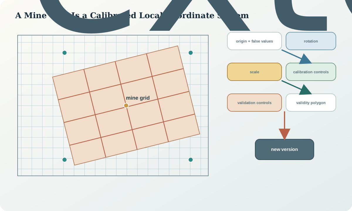
A two-dimensional similarity transformation preserves shape through one scale, one rotation and two translations. It is appropriate only when the relationship is adequately represented by those parameters. An affine model adds independent scale or shear terms; a higher-order warp may fit residuals while destroying geometric meaning. Model complexity must follow evidence and decision, not the desire for zero residuals.
Control points should span the project, be stable, independently observed and correctly identified in both systems. Points clustered near the origin cannot constrain rotation and scale across a wide area. Calibration controls and validation controls must be separated so that fit residuals are not mistaken for prediction performance.
Reference frames and metadata
The mine-grid definition records external source CRS, coordinate epoch if relevant, source and local axis order, local origin in both systems, rotation reference and sign, scale, false easting and northing, Z treatment, vertical reference, parameter units, control identifiers, fitting method, validity polygon, residual statistics, parameter covariance, version and responsible review role.
Historical grid versions remain immutable. If control improves or the operation changes, create a new version and a transformation between versions. Never update parameters in place while retaining the same grid name, because every historical drawing and database coordinate would silently change meaning.
Quantitative reasoning
One declared convention is \mathbf{x}_m=\mathbf{f}+s\mathbf{R}(\theta)(\mathbf{x}_g-\mathbf{x}_0), where \mathbf{x}_g is the external-grid coordinate, \mathbf{x}_m the mine-grid coordinate, \mathbf{f} the false-coordinate vector and \mathbf{R}(\theta) the stated rotation matrix. The inverse uses the inverse rotation and scale; rotation sign must be tested with a simple known vector.
Fit parameters by weighted least squares only when weights represent defensible coordinate uncertainty. Inspect coordinate residuals, standardised residuals, leverage and leave-one-out prediction. A low root-mean-square fit with one high-leverage point can be fragile.
Evidence and uncertainty
Evidence includes original survey control, mark descriptions and status, dual-coordinate observations, adjustment reports, design-grid definition, historical parameter sheets, transformation code tests, independent validation controls and dependency inventory. Screenshot measurements or drawing ticks are weak evidence and should not calibrate a high-accuracy grid.
Uncertainty grows outside the control hull. Parameter covariance creates spatially varying prediction uncertainty even when the model is linear in coordinates. Add source coordinate uncertainty and local control uncertainty; do not report the fit residual alone as transformation accuracy.
Transformation and control
The controlled calibration checks point identity, stability, CRS and vertical compatibility; plots control geometry; fits a declared model; reviews residual patterns; withholds validation points; tests inverse and known vectors; defines validity extent; versions parameters and updates dependent products through lineage.
Stop if controls are collinear or clustered, point identities conflict, residuals show systematic curvature, vertical references differ, the inverse is undocumented, or the requested location lies outside the validated extent. A more flexible model is not automatic permission to proceed.
Interfaces and data
The exchange contract includes mine_grid_id, version, source_crs, source_epoch, origin, false coordinates, rotation convention, scale, matrix, Z operation, validity geometry, controls, fit and prediction statistics, checksum and transformation direction. Deliver both forward and inverse test cases with expected values.
Operational systems should store the authoritative external coordinate alongside local coordinates or preserve a stable link to it. A local coordinate exported alone is unsafe because its project, grid version and vertical reference can be lost.
Integration checkpoint
The checkpoint passes when another reviewer can reconstruct the local grid from parameters, independently transform a test point in both directions and explain how uncertainty changes across the extent. Control points used for validation are visibly separate from those used for fitting.
A residual map should reveal translation, rotation, scale, shear or local-control signatures. If the chosen model cannot explain the pattern within decision tolerance, the correct result may be that no single transformation is fit.
Synthetic worked example
A synthetic mine grid uses false coordinates 10000, 20000, a small rotation and a scale close to one. Six dual-coordinate controls are available; four surround the active area, one lies near the centre and one is far outside. A similarity fit performs well inside the hull, while the remote point has a directional residual inconsistent with the others.
The learner withholds the remote point, investigates its history and limits the grid validity rather than adding a polynomial term. All parameter values and controls are synthetic and provide no engineering control.
Practice task
Fit a two-dimensional similarity transformation to a synthetic dual-coordinate table. Use separate calibration and validation controls, report parameter covariance, map residual vectors, test a known unit vector and inverse, and define a validity polygon. Compare with an affine candidate but reject or accept it from evidence.
Submit a versioned parameter record, machine-readable test cases and a migration note for downstream layers.
Common failure modes
The following failures are treated as evidence or process defects, not cosmetic issues:
- using a local-grid name without parameters.
- reversing rotation sign.
- calibrating with clustered or misidentified controls.
- reporting fit residual as prediction accuracy.
- extrapolating far beyond the control hull.
- adding polynomial flexibility to hide gross errors.
- changing parameters without a new grid version.
For each failure, preserve the original evidence, identify its downstream reach, define a discriminating test and record whether the case is corrected, rejected or still unresolved.
Review questions
- What properties does a similarity transformation preserve?
- How does control geometry affect parameter reliability?
- Why separate calibration and validation controls?
- How does parameter covariance create spatially varying uncertainty?
- When should an affine model be considered or rejected?
Answer with definitions, evidence, a calculation or test where relevant, and the condition that would reverse the conclusion. A product screenshot or unexplained code is not an answer.
Assessment artefact
The assessment artefact is a mine-grid definition, calibration and validation package. It includes immutable source controls, model choice, parameter convention, covariance, residual vectors, holdout performance, validity polygon, forward and inverse cases, version history and downstream dependency plan. It is a teaching calibration, not an authorised site grid.
Sources and further reading
- GDA2020 Technical Manual, version 1.8, official technical definitions, formulae and worked computations; confirm the current version before operational use.
- EPSG Dataset terms and completeness guidance, authoritative cautions on complete CRS descriptions, parameter conventions and dataset use.
- Transverse Mercator coordinate operation method, authoritative registry entry for parameters, formulae and implementation notes.
- Well-known text representation of coordinate reference systems, official standard landing page for structured CRS and coordinate-operation definitions.