E1 · Publication Volume 23
Coordinate Transformation
Helmert intuition, grid transformations and error vectors
Learning objectives
distinguish coordinate conversion from datum transformation; decompose a concatenated operation; understand translation, rotation, scale, grid shift and epoch terms; choose an operation by area and accuracy; and validate results beyond round-trip testing.
The objective is transferable reasoning, not operation of a named product or performance of regulated survey work. Every real decision must use current applicable requirements, authorised control and competent review.
Decision context
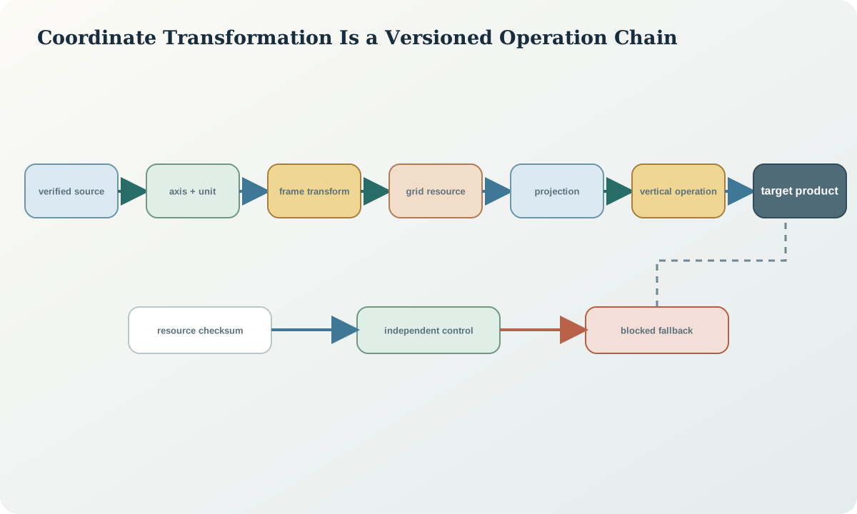
The decision is which coordinate operation transforms a verified source CRS to a verified target CRS for a stated area, epoch and accuracy. A conversion changes coordinate system without changing datum, such as geographic to projected. A transformation changes datum or reference frame and carries empirical or model uncertainty. A concatenated operation can include axis swaps, unit conversions, projection, frame transformation, grid interpolation and vertical conversion.
The shortest path is not necessarily the most accurate or appropriate. The analyst records every step, resource, parameter convention, area of use, stated operation accuracy, dimensionality and epoch assumption. An automatically selected path is a candidate that must be inspected.
Core concept
A seven-parameter similarity transformation in geocentric space uses three translations, three small rotations and scale. Position-vector and coordinate-frame conventions use different rotation signs; names and parameter conventions must match. Grid transformations interpolate spatially varying offsets and require the correct grid file, direction, interpolation and coverage. Time-dependent operations add parameter rates or deformation models.
Operation direction matters. Some transformations are formally reversible, while grids may require iterative inverse evaluation or provide distinct reverse resources. A round trip through the same wrong assumptions can return to the starting value and still be spatially wrong.
Reference frames and metadata
The operation record contains source and target CRS definitions, operation identifier and version, ordered steps, parameters with units and convention, resource filenames and checksums, interpolation, source and target epochs, point coordinate epoch, area of use, stated accuracy, missing-grid policy, software-independent test points, runtime version and execution timestamp.
Resources are part of the scientific method. If a required grid is missing, silently falling back to a lower-accuracy operation changes the result. The system must fail or record an explicitly reviewed downgrade according to the decision contract.
Quantitative reasoning
A compact geocentric similarity form is \mathbf{x}_t=\mathbf{t}+(1+m)\mathbf{R}\mathbf{x}_s, where \mathbf{t} is translation, m scale and \mathbf{R} the rotation matrix under a declared convention. A grid operation can be represented as \phi_t=\phi_s+\Delta\phi(\phi_s,\lambda_s) and \lambda_t=\lambda_s+\Delta\lambda(\phi_s,\lambda_s).
For a time-dependent parameter p, use p(t)=p(t_0)+\dot p(t-t_0) only under the operation definition. Propagate input covariance through the operation Jacobian and add operation uncertainty without double-counting shared control. Numeric agreement across two implementations is useful but not independent if both use the same library or dataset.
Evidence and uncertainty
Evidence includes authoritative operation definitions, parameter and grid resources, release notes, source and target control, independent check points, execution logs, test vectors, epoch metadata and dependency checksums. A transformed output without the selected operation is not reproducible.
Uncertainty may vary across a grid and increase near boundaries or sparse control. Parameter uncertainty, interpolation, temporal propagation and local deformation can be systematic. Report operation accuracy separately from feature capture and source survey accuracy.
Transformation and control
The controlled pipeline verifies source definition, chooses operation candidates by area and accuracy, confirms all resources, tests published or independently computed vectors, transforms an immutable copy, validates independent controls, reviews residual vectors, tests inverse behaviour, records provenance and locks the delivered version.
Stop on missing source definition, ambiguous axis, missing epoch, unavailable grid, area-of-use failure, unexpected fallback, control mismatch or dimensionality loss. A transformation should never silently discard height or epoch information.
Interfaces and data
The transformation service contract accepts explicit source and target definitions, operation preference, coordinate epoch, dimensionality and error policy. It returns selected operation, ordered steps, resources, warnings, output coordinates, operation accuracy, validation status and provenance. Default CRS, default epoch and silent axis normalisation are prohibited for controlled workflows.
Batch processing keeps row identity and per-row status. A single invalid coordinate must not shift subsequent records or disappear. Partial success is delivered with an error table and unchanged raw inputs.
Integration checkpoint
The checkpoint passes when the learner can explain each operation step, reproduce test points independently and show that controls validate the target position rather than merely the reverse calculation. Resource checksums and epoch decisions are present.
Compare at least two plausible operation paths where available. If their difference matters to the decision, the selection basis and residual evidence become part of the deliverable.
Synthetic worked example
A synthetic set of geographic coordinates must move from an earlier static datum to a later static datum and then to a projected grid. Candidate Path A applies a similarity transformation then projection; Path B applies a conformal-plus-distortion grid then projection. Independent target controls show a spatial gradient under A and smaller, structureless residuals under B within the grid coverage.
One feature outside coverage is not transformed by extrapolation. It is blocked for additional evidence. All coordinates, residuals and decision tolerances are synthetic.
Practice task
Build a coordinate-operation graph for a synthetic source geographic 3D CRS, target projected 2D CRS and target vertical datum. List every conversion and transformation, required resource, dimensional effect, epoch assumption and validation control. Execute hand-checkable test vectors or documented calculations for at least two steps.
Submit the graph, operation manifest, checksums, per-point status, residual comparison and failure-policy test.
Common failure modes
The following failures are treated as evidence or process defects, not cosmetic issues:
- treating conversion and transformation as synonyms.
- using the wrong rotation convention.
- allowing silent missing-grid fallback.
- omitting coordinate epoch.
- using round trip as the only validation.
- discarding the height dimension.
- reporting operation accuracy as total feature accuracy.
For each failure, preserve the original evidence, identify its downstream reach, define a discriminating test and record whether the case is corrected, rejected or still unresolved.
Review questions
- What distinguishes a coordinate conversion from a datum transformation?
- Why can two seven-parameter conventions produce opposite rotation signs?
- How do grid resources become part of provenance?
- Why can a round trip pass under a wrong definition?
- Which uncertainty terms belong to the operation rather than the feature?
Answer with definitions, evidence, a calculation or test where relevant, and the condition that would reverse the conclusion. A product screenshot or unexplained code is not an answer.
Assessment artefact
The assessment artefact is a reproducible coordinate-operation pipeline. It includes verified endpoints, ordered operations, parameters and conventions, resource hashes, epoch logic, test vectors, independent controls, residuals, blocked points, per-row status and an immutable output manifest. It makes every fallback and dimensional change visible.
Sources and further reading
- Geodetic transformations and conversions, official description of parameter and grid-based transformation options.
- GDA2020 Technical Manual, version 1.8, official technical definitions, formulae and worked computations; confirm the current version before operational use.
- Time-dependent Position Vector transformation, authoritative registry entry illustrating epoch-dependent transformation parameters.
- Datum Matters: coordinate transformations, official concise comparison of conformal and distortion-aware transformation paths.
- Well-known text representation of coordinate reference systems, official standard landing page for structured CRS and coordinate-operation definitions.