E1 · Publication Volume 23
Spatial Accuracy and Error Budgets
source, transformation and survey accuracy and display precision
Learning objectives
separate accuracy, precision, resolution and display rounding; construct a spatial error budget across observation, control, transformation, interpolation and representation; account for covariance and systematic bias; and compare uncertainty with decision tolerance.
The objective is transferable reasoning, not operation of a named product or performance of regulated survey work. Every real decision must use current applicable requirements, authorised control and competent review.
Decision context
The decision is whether delivered spatial information is fit for a defined use. Accuracy describes agreement with an accepted reference under stated conditions; precision describes repeatability or numerical spread; resolution describes distinguishable detail or sampling support; display precision controls formatting. None can substitute for another.
An error budget begins with the decision variable and tolerance, not the available decimal places. The analyst maps every operation from observation to delivery, identifies random and systematic terms, shared dependencies, validation evidence and sensitivity of the decision to position. A result can be fit for regional planning and unfit for engineering control without contradiction.
Core concept
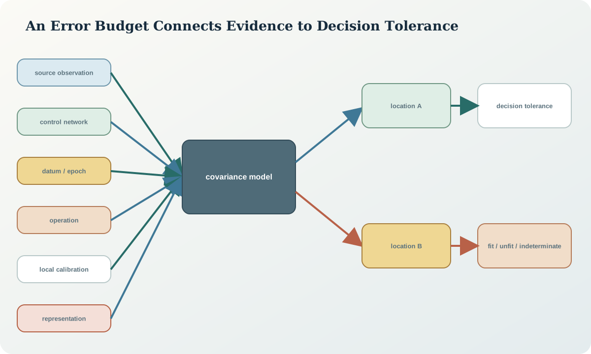
Spatial uncertainty is a distribution or bounded statement in two or three dimensions. Horizontal components may be correlated and represented by covariance or an error ellipse. Vertical uncertainty follows a different reference and often different evidence. Systematic offsets, rotations, scale errors and datum mismatches are not reduced by averaging more features.
Resolution limits what patterns can be supported. A high-accuracy point can sample a phenomenon that varies between points; a fine raster can contain low-accuracy positions. Positional uncertainty, attribute uncertainty, classification uncertainty and model uncertainty should remain separate until a decision model explicitly combines them.
Reference frames and metadata
The accuracy record states reference, confidence level, metric, dimensionality, spatial and temporal support, population or sample, control independence, datum and epoch, vertical reference, method, exclusions and date. Values such as ±0.1 m are incomplete without distribution, confidence and reference.
Metadata should distinguish source_accuracy, transformation_accuracy, interpolation_uncertainty, representation_resolution, coordinate_precision, validation_residual and total_decision_uncertainty. A provider statement is evidence, but independent checks determine applicability to the delivered subset.
Quantitative reasoning
For an operation chain \mathbf{y}=f(\mathbf{x}), first-order covariance propagation is \Sigma_y=J\Sigma_xJ^T+\Sigma_{op} when the added operation term is independent. For a linear combination with correlated scalar terms, u_y^2=\sum_i a_i^2u_i^2+2\sum_{i<j}a_i a_j\operatorname{cov}(x_i,x_j).
A root-mean-square residual RMSE=\sqrt{\sum_i r_i^2/n} summarises magnitude but hides direction and spatial pattern. Report component bias, standard deviation, robust summaries and residual maps. Confidence conversion requires an assumed distribution and degrees of freedom; do not apply a universal multiplier blindly.
Evidence and uncertainty
Evidence includes instrument specifications, calibration, survey adjustment, control covariance, transformation accuracy, grid reliability, residual vectors, raster resolution, interpolation diagnostics, repeated observations, holdout controls and decision sensitivity. Controls used to fit a transformation are not independent validation evidence.
Missing metadata should widen or block the budget rather than be assigned zero. Conservative bounds may be used if justified and labelled. Synthetic default accuracies are prohibited: every numeric term needs a traceable source or measured validation.
Transformation and control
The controlled budget identifies each term, unit, distribution or bound, correlation, spatial variability, evidence and owner; transforms terms to a common frame; runs sensitivity analysis; validates against independent controls; and compares the resulting uncertainty with the decision tolerance and consequence.
Stop when a dominant term is unknown, covariance would materially change the result, controls are not independent, systematic residual structure remains, the decision threshold is closer than the supported uncertainty, or display rounding could mislead users.
Interfaces and data
The data contract carries uncertainty as structured fields rather than a free-text note: metric, confidence, covariance or ellipse, vertical component, source, method, support, validity extent and version. Derived products link to the budget version. User interfaces display uncertainty and decision status without implying that more digits mean more confidence.
APIs should not return a single accuracy value that mixes source, operation and validation metrics. When a coordinate is transformed, preserve source accuracy and report the additional operation contribution and total only under stated dependence assumptions.
Integration checkpoint
The checkpoint passes when the learner can trace the dominant uncertainty term, explain every correlation assumption, reproduce total covariance and show how the decision changes across plausible bounds. Residual vectors have been inspected for bias and spatial structure.
A good budget may conclude that the decision is indeterminate. That is a valid scientific outcome and triggers additional control, a less sensitive decision or a wider safety margin rather than invented certainty.
Synthetic worked example
A synthetic collar coordinate has 0.06 m horizontal source uncertainty, a transformation contributes a spatially varying 0.04 m term, and local-grid calibration adds correlated translation and rotation uncertainty. Treating all terms as independent produces a compact total, but parameter covariance increases uncertainty toward the project edge.
A target intersection has only 0.10 m clearance under one scenario, so the coordinate package is not declared fit for that decision even though map display looks precise. All numbers and tolerances are synthetic.
Practice task
Construct a two-dimensional error budget for a synthetic control-to-delivery chain with at least six terms, including one correlated pair, one systematic bound and one spatially varying term. Propagate covariance to three locations, compare results with two decision tolerances and design an independent validation sample.
Submit the dependency graph, equations, assumptions, residual maps, sensitivity ranking and fitness statement.
Common failure modes
The following failures are treated as evidence or process defects, not cosmetic issues:
- equating decimal places with accuracy.
- adding correlated terms as independent.
- using fit controls as validation.
- reporting RMSE without bias or spatial pattern.
- assigning zero to unknown uncertainty.
- mixing vertical and horizontal metrics.
- claiming one accuracy for every use.
For each failure, preserve the original evidence, identify its downstream reach, define a discriminating test and record whether the case is corrected, rejected or still unresolved.
Review questions
- How do accuracy, precision, resolution and display precision differ?
- When must covariance be included?
- Why can RMSE conceal a serious spatial pattern?
- How should unknown dominant uncertainty affect a decision?
- Why is fitness for purpose decision-specific?
Answer with definitions, evidence, a calculation or test where relevant, and the condition that would reverse the conclusion. A product screenshot or unexplained code is not an answer.
Assessment artefact
The assessment artefact is a spatial accuracy and decision-fitness dossier. It contains the operation chain, uncertainty terms and evidence, covariance model, spatial propagation, independent validation, residual diagnostics, sensitivity, decision tolerances and an explicit fit, unfit or indeterminate conclusion.
Sources and further reading
- GDA2020 Technical Manual, version 1.8, official technical definitions, formulae and worked computations; confirm the current version before operational use.
- EPSG Dataset terms and completeness guidance, authoritative cautions on complete CRS descriptions, parameter conventions and dataset use.
- Geodetic transformations and conversions, official description of parameter and grid-based transformation options.
- AUSGeoid2020, official model scope, height relationship, coverage and uncertainty information.