D3 · Publication Volume 19
Feedback to the Resource Model
learning loops, domain changes and bias correction
Learning objectives
By the end of this lesson, the learner should be able to convert operational observations into model-validation evidence; distinguish local correction from transferable learning; detect conditional bias and domain failure; update data, density, geometry or estimation rules through controlled changes; test revised hypotheses prospectively; and document what reconciliation can and cannot imply for a resource model.
Operational data provide a dense but selective view of mined areas. They can reveal contact geometry, short-range variability, density behaviour, sampling bias and model performance. They are not automatically suitable for replacing exploration data or extrapolating beyond mined conditions. Feedback must preserve support, selection, timing and survivorship effects.
Evidence package from operations
Assemble validated control samples, mapped contacts, surveyed extraction, destination events, stockpile and feed measurements, reconciliation arcs, deviations and uncertainty. Each item needs lineage and a statement of what it observes. Separate direct geological evidence from outcomes influenced by mining and processing.
Freeze the long-term model version that made the forecast and the later evidence cut-off. Match comparable volumes. Include areas with normal performance and adverse results; a package selected only from anomalies cannot estimate overall bias.
Local correction versus model learning
A local correction changes an upcoming boundary or parcel using nearby evidence. Model learning changes a reusable assumption: domain geometry, continuity, density relation, estimation neighbourhood, classification criterion or sampling protocol. The evidence threshold for transferable learning is higher because the consequence extends beyond the observed area.
Ask whether the pattern repeats across independent locations, aligns with a geological mechanism, survives support and timing corrections, and predicts held-out observations. If not, retain it as a local limitation or hypothesis. Do not make the resource model chase every short-term fluctuation.
Spatial and conditional bias
Compare predicted and later better-informed quantities by matched spatial units. Examine mean bias, slope, conditional bias, boundary displacement and spatial residual patterns. Global agreement can coexist with local smoothing: high grades underpredicted and low grades overpredicted. Conversely, a global shift may arise from mining a non-representative part of the deposit.
Stratify by domain, confidence, data spacing, distance to contact and estimation pass. Use weights appropriate to the validation question. Avoid treating the mined sequence as a random sample; extraction order is selected by access, value and schedule.
Domain and geometry feedback
Map observed contacts against predicted surfaces. Record signed distance in a geologically meaningful direction, contact type, observation uncertainty and whether the long-term surface was informed locally. Repeated coherent offsets may justify a trend or geometry revision. Alternating offsets may indicate short-range complexity that should increase uncertainty rather than produce a wavy surface.
Test topology as well as distance. New evidence may split, connect, truncate or reactivate a domain. Preserve alternative scenarios where exposure cannot distinguish them. A geometric change should trigger dependent volume, estimation and classification reviews.
Grade, continuity and support feedback
Compare control samples with long-term expectations only after accounting for method, support and preferential placement. Re-estimate matched mined volumes using the information available at the historical cut-off, then compare with a short-term or exhaustive proxy on common support.
Operational data can inform short-range continuity and nugget behaviour, but blast-hole or face samples may contain method-specific error. Model sample type explicitly, perform contact and bias tests, and avoid combining sources until compatibility is supported. A finer pattern inside mined areas does not guarantee the same continuity in unmined sectors.
Density and material-state feedback
Compare in-situ density observations with volume-derived and weighed masses only through a state model. Broken bulk density, swell, moisture and voids are not replacements for in-situ density. Surveyed mined volume and dry mass can nevertheless test domain-scale tonnage predictions when inventory and measurement uncertainty are controlled.
If a persistent mass bias is domain-specific, investigate density sampling coverage, compositing, moisture correction and geological membership. Revise the density model only when the causal chain is supported. Record whether the update changes historical estimates, future predictions or both.
Controlled model change
Open a change proposal with hypothesis, evidence, affected domain and extent, expected consequences, alternatives and validation plan. Rebuild from controlled inputs rather than editing released blocks. Produce a difference package for geometry, tonnes, grade, contained quantity, classification and uncertainty.
Classify the change as data correction, implementation correction, new evidence, interpretive revision or method revision. Independent review should focus on the causal claim and downstream consequences. Release only after acceptance tests pass, and retain the predecessor for reproducibility.
Prospective testing and learning closure
Reserve later parcels or sectors for prospective validation. State expected signatures: smaller directional contact bias, improved matched-volume factor, reduced wet-hole grade bias, or better uncertainty calibration. A revision that improves the same data used to design it is not yet validated.
Monitor benefits and unintended effects. Improved global reconciliation may worsen boundary classification, or a conservative rule may reduce dilution while increasing ore loss. Close the learning loop only when the predicted effect appears on new evidence, limitations are updated and the rule is either adopted, modified or rejected.
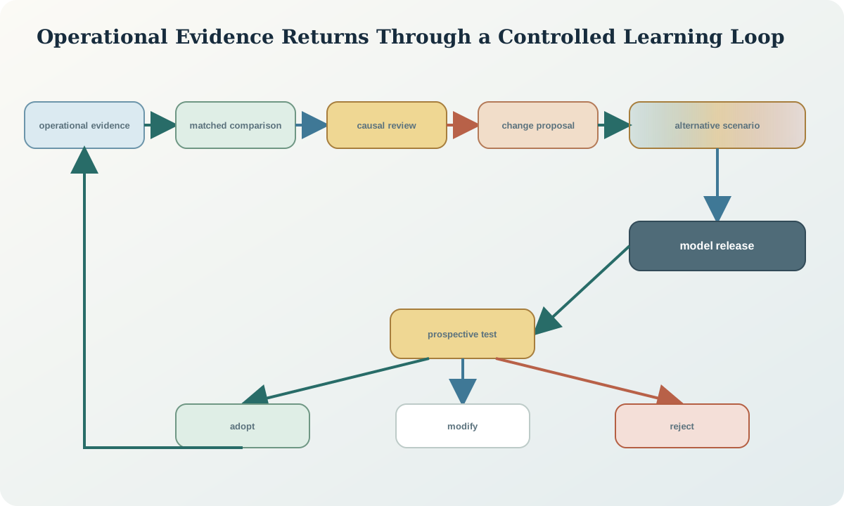
Synthetic capstone and completion record
Across four synthetic panels, the long-term boundary lies 3–5 m west of later mapped contacts in one structural domain. The direction is coherent, survey uncertainty is below one metre, and the pattern persists after control-sample method differences are removed. Grade residuals show no separate global bias. A fifth panel is held out.
A geometry hypothesis revises the fault-adjacent trend while preserving an alternative truncation scenario. The prospective fifth panel shows a smaller signed contact error without worsening stable sectors. The completion record links observations, reconciliation results, change proposal, model differences, held-out test and remaining uncertainty. It does not claim that the revision applies outside the tested domain.
Sources
- Mineral-resource and mineral-reserve estimation best-practice guidelines, treats reconciliation as evidence for data, sampling, modelling and parameter validation.
- International reporting template, 2024 edition, provides principles for transparent assumptions, confidence and material technical change.
- Reconciliation along the mining value chain, links end-to-end measurement, causal investigation and continuous improvement.
- Provenance data model, provides a general structure for derivations, revisions, invalidations and traceable evidence relationships.