D4 · Publication Volume 20
Mine Survey and Spatial Control
control networks, voids, as-built geometry, accuracy and mine grids
Learning objectives
By the end of this lesson, the learner should be able to distinguish datum, coordinate reference system, mine grid and local frame; explain control-network design and adjustment; separate survey, positional and relative uncertainty; manage set-out, as-built and void evidence; audit transformations and vertical references; and specify spatial acceptance criteria for cross-discipline exchange.
Coordinate contract
Every spatial exchange begins with a coordinate contract: reference system, datum realisation, epoch where relevant, projection, axis order, units, vertical datum, geoid or height model, mine-grid definition, transformation version and physical reference. A bare easting, northing and elevation is incomplete. “Local grid” is not a definition.
Separate external datum coordinates from working mine-grid coordinates and equipment-local frames. Transformations may include translation, rotation, scale and height treatment. Store direction and parameters, residuals, control used, valid extent and uncertainty. Never infer a transform from visually aligned drawings.
Control networks and monument state
Control provides the spatial reference for set-out and as-built observations. Network design uses stable monuments, suitable geometry, redundancy and connection to the required datum. Surface and underground networks face different visibility, disturbance and propagation constraints. Place control outside expected movement where feasible and monitor its stability.
Maintain a monument register with identity, coordinates, uncertainty, mark type, description, observation history, adjustment, condition and status. A destroyed or moved mark is not silently replaced under the same identity. Distinguish original observation from adjusted coordinate.
Survey, positional and relative uncertainty
Survey uncertainty describes quality arising from measurements, network geometry and constraints within a survey. Positional uncertainty includes the uncertainty of the datum realisation to which the survey connects. Relative uncertainty concerns the relationship between two marks. These quantities answer different questions and should be expressed at a declared confidence level.
Propagate covariance where the decision depends on differences or transformed positions. Independent scalar error budgets can over- or underestimate relative geometry. Compare uncertainty with the tolerance of the specific task: breakthrough, grade boundary set-out, wall conformance and regional mapping have different requirements.
Observation, adjustment and quality control
Use redundant observations, calibrated equipment, environmental corrections and documented setup. A least-squares adjustment can estimate coordinates and uncertainty and reveal inconsistency, but it cannot repair misidentified marks or wrong instrument heights. Inspect residuals, network geometry, constraints and statistical tests.
Independent checks should not reuse the same setup or copied coordinates. Close traverses and levelling runs where appropriate; repeat occupations; compare independent methods; audit field notes and raw files. Keep rejected observations with reason and authority.
Set-out and design transfer
Set-out transfers a controlled design object to the field. The package identifies design version, point or line role, coordinate basis, offsets, elevation reference, tolerance, access and hazards. Verify that the design is current and that transformation is valid over the work area. Mark the physical reference used—centreline, crest, toe, collar, floor or another object.
After set-out, record what was marked, how, when and with what uncertainty. A peg or paint mark is not self-describing. Field movement, blast damage or construction can invalidate it; establish inspection and supersession rules.
As-built geometry and conformance
As-built survey observes realised geometry. Sources include total station, levelling, positioning systems, photogrammetry, laser scanning, sonar and other methods selected for range, visibility, surface and hazard. Each produces a sample, not a complete surface. Occlusion, water, dust and registration matter.
Conformance requires a controlled comparison model: same coordinates, time, object definition and clipping. Report signed distance, volume or profile difference with measurement uncertainty and unobserved area. Distinguish excavation deviation from registration and modelling artefacts.
Underground voids and inaccessible areas
Underground voids may be surveyed directly, remotely or inferred from production and historical evidence. Maintain observed, interpolated and unknown surface status. Do not close holes in a mesh without marking the reconstruction. Old workings and unrecorded voids require hazard treatment beyond geometric convenience.
For stope or cavity volume, state scan position, coverage, line of sight, registration, water or broken material, filtering and closure method. Compare design and void over the shared observed extent before assigning overbreak or underbreak.
Vertical control and gravity-dependent data
Ellipsoidal height, orthometric height, local reduced level and depth are not interchangeable. Record the vertical datum and model used. Underground levelling may accumulate error through constrained paths. Shaft and borehole transfers need independent checks and corrections appropriate to the method.
Vertical inconsistency affects drainage, hydraulic head, bench and floor control, gravity data, volumes and breakthrough. A small horizontal residual does not validate height. Test horizontal and vertical components separately.
Temporal state, movement and deformation
Coordinates describe an epoch. Control marks can move through slope deformation, subsidence, construction or tectonic motion. Deformation monitoring needs stable reference, repeated method, uncertainty and a causal model. Do not use a moving reference to prove that another point is stable.
Store event time, observation time and processing time. A current map assembled from surveys of different dates may depict a geometry that never existed simultaneously. Time-stamp surfaces and state models.
Data exchange and audit
Use persistent object identifiers, metadata, coordinate contract, units, precision, uncertainty, observation method, raw-file links and checksum. Exchange neutral formats where suitable while retaining native evidence. Test axis order, sign, unit, scale and sample points after every conversion.
The receiving discipline performs an acceptance check rather than assuming a survey label guarantees fitness. Survey authority remains with qualified roles; geology or planning staff should not approve control adjustments by appearance.
Synthetic worked example
A synthetic underground breakthrough uses a mine-grid design derived from an external datum. Surface control has positional uncertainty of 18 mm horizontally and 24 mm vertically; the underground network has survey uncertainty of 32 mm at the final station. A legacy transform applies a height offset but its valid extent does not include the new portal.
The review refuses to combine the scalar uncertainties blindly or extend the legacy transform. It establishes new redundant connection observations, calculates the adjusted covariance, performs an independent underground check and defines relative uncertainty across the breakthrough points. The issued set-out package includes both grid and datum identifiers and a hold point before final advance.
Practice and survey-control record
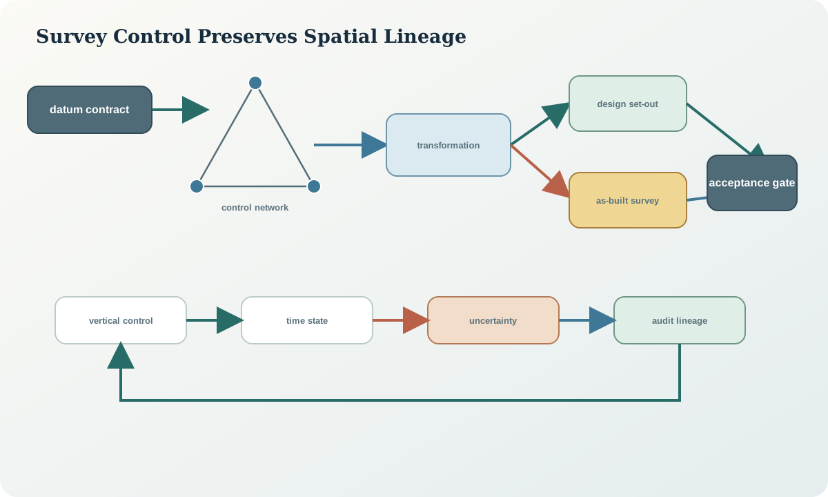
Audit a synthetic file containing swapped axes, an unspecified height, a local rotation and mixed observation dates. Correct the metadata without inventing coordinates. Then prepare a control record listing marks, observations, adjustment, uncertainty, transformation, valid extent, independent check, set-out object, as-built state and receiving acceptance.
A passing record makes coordinate lineage reconstructable and never claims survey authority from a visual overlay.
Sources
- Standard for the Australian Survey Control Network, Intergovernmental Committee on Surveying and Mapping.
- Guideline for conventional traverse surveys, Intergovernmental Committee on Surveying and Mapping.
- Mines survey: code of practice, WorkSafe Western Australia.
- Emergency planning guidance referencing current mine survey plans, New South Wales Resources Regulator.