D4 · Publication Volume 20
Interfaces with Geology Systems
shared domains, hazards, data exchange and responsibility boundaries
Learning objectives
By the end of this lesson, the learner should be able to map geology-to-engineering interfaces; distinguish shared object, derived parameter, advice, decision and approval; design versioned exchange contracts; protect competence and responsibility boundaries; manage conflicting models and changes; and assemble an integrated review package for geometry, ground, water, survey, ventilation, schedule and risk.
Interface objects and semantic contracts
Disciplines often exchange surfaces, solids, intervals, points, schedules and documents while assigning different meanings. A geological fault surface represents an interpretation with uncertainty; a geotechnical structure may be a design input; an exclusion surface is a control; an as-built surface is an observation. Similar geometry does not make these objects interchangeable.
For every interface object, define identifier, type, purpose, coordinate and vertical basis, support, units, domain, time, source version, uncertainty, status, owner by role, acceptance and supersession. Use a semantic contract alongside the file format. A successful import does not prove correct meaning.
Observation, interpretation, parameter and design
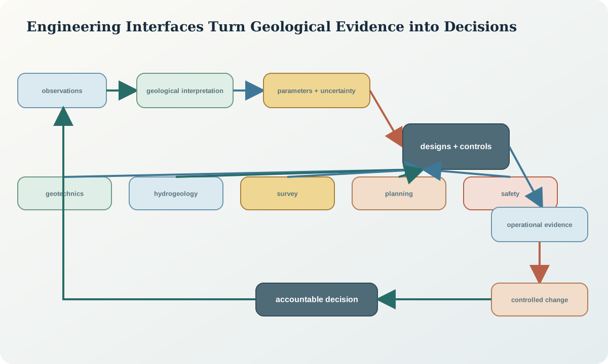
Preserve the transformation chain. A mapped discontinuity is an observation. Grouping it into a set is interpretation. Assigning a shear-strength range is parameter inference. Using it in a slope sector is a design input. Selecting geometry and controls is an engineering decision. Each step has evidence, method and authority.
Avoid writing derived design parameters back into raw geology fields. Keep original observations immutable and link revisions. A model can be corrected without falsifying what was known earlier. This is essential for audit and learning.
Responsibility and competence boundaries
Responsibility follows decision authority, not file ownership. Geologists describe geological evidence and its uncertainty; survey roles establish and verify spatial control; engineering roles design excavations, support and systems; hydrogeology roles assess water; ventilation and safety roles control specialised hazards; operations implement within authorised conditions. Local law and organisational arrangements determine exact duties.
An interface register records who provides information, who reviews fitness, who decides, who approves and who must be consulted or informed. It should prevent both gaps and accidental transfer of authority. “Reviewed by geology” cannot imply approval of a slope, and “surveyed” cannot imply safe access.
Shared domains and crosswalks
Geological, geotechnical, hydrogeological, resource, planning and operational domains differ by purpose. Maintain crosswalk tables and spatial relationships rather than forcing one universal code. A geological unit may split into two ground domains by weathering, while one hydraulic domain crosses several lithologies along a fracture network.
Record one-to-many and many-to-many mappings with validity. When a boundary changes, identify dependent parameters and designs. Do not cascade changes automatically where professional review is required.
Data quality and acceptance gates
Acceptance tests cover identity, schema, range, units, coordinate reference, topology, time, completeness, uncertainty, provenance and decision fitness. Test samples independently after transformation. Require explicit rejection or conditional acceptance rather than silently repairing values.
Fitness is purpose-specific. Sparse mapping can be adequate for a regional hypothesis but not a bench release. A coarse water model can inform monitoring layout but not pump selection. Record the accepted use and excluded use.
Conflicting models and uncertainty
Different disciplines may hold legitimate competing models. A fault interpreted as continuous in geology may be segmented in geotechnical mapping; hydraulic response may support either conduit or barrier behaviour. Preserve alternatives, identify the decision consequence and design a discriminating observation.
Do not resolve conflict by majority or by choosing the most detailed model. Compare source support, scale, assumptions and predictive performance. Escalate where consequences exceed the authority of the interface team.
Change propagation and configuration control
A change graph links source observation, model object, parameter, design, schedule, control and monitored response. When one node changes, assess affected descendants. Use impact status—unaffected, reviewed, update required, suspended or superseded—and record evidence.
Release bundles should be immutable and reproducible. Include manifest, object versions, checksums, coordinate contract, change log, validation results and approvals. Prevent partial updates in which geometry changes but schedules or controls retain old references.
Communication and operational translation
Technical nuance must survive translation into field instructions. Use maps, sections, 3D views and tables with stable identifiers, scale, orientation, effective time and clear action. Separate observed, inferred and uncertain features visually and textually. Confirm receipt and understanding at handoff.
Field observations return through structured channels with location, time, method, evidence and urgency. An informal message may trigger immediate safety action, but the observation still needs controlled capture. Close the loop by telling the observer how evidence affected the model or decision.
Assurance, audit and learning
Assurance tests whether critical work and controls meet requirements. Independent review should have suitable competence and enough source evidence to challenge assumptions. Audit traces a representative decision from observation to action and back. Metrics include unresolved interface actions, stale objects, rejected exchanges, late changes and control verification—not only file delivery.
Learning compares forecasts with realised geometry, ground, water, airflow, schedule and material outcomes. Update models at the correct level. A local deviation may need a local correction; repeated conditional bias may require domain or process change.
Synthetic capstone
A synthetic next-phase design deepens a surface excavation while developing an underground access beneath its eastern wall. New mapping shifts a weak corridor 12 m west; head rises in one nested piezometer; a control-network mark near the crest shows movement; and the underground ventilation model still uses the earlier drive alignment.
The integrated review quarantines affected objects rather than issuing a universal new model. Survey verifies whether the mark or ground moved. Geotechnical and hydrogeological roles test corridor and pressure scenarios. Planning marks the surface cut and underground crosscut conditional. Ventilation updates only after accepting the as-built alignment. Safety review verifies exclusion and communication controls. The package records decisions and unresolved evidence without assigning ownership to a company or person.
Completion package
Prepare an integrated package containing: problem statement; synthetic context; object and coordinate contracts; geological, ground and water scenarios; surface and underground geometry; survey state; ventilation and services dependencies; schedule constraints; high-consequence events and critical controls; interface matrix; change graph; unresolved questions; decision record; and approval boundaries.
The package passes when every conclusion is conditional on traceable evidence, quantities carry units and support, uncertainty changes decisions where material, and no discipline is represented as approving work outside its competence. It remains a teaching artefact and not a design for any real mine.
Sources
- Ground control for Western Australian mining operations: code of practice, WorkSafe Western Australia.
- Mines survey: code of practice, WorkSafe Western Australia.
- Introduction to ground-water hydraulics, United States Geological Survey.
- Tools and solutions for mine safety and health, National Institute for Occupational Safety and Health.