F1 · Publication Volume 30
Project Charter and Area of Interest
objectives, boundaries, users, professional responsibility, AOI and non-goals
Learning objectives and boundary
- Explain objectives, boundaries, users, professional responsibility, AOI and non-goals as an auditable evidence problem.
- Separate source observations, controlled derivatives, interpretation and decision state.
- Apply identity, spatial, semantic, lineage, quality and review checks.
- Produce a signed-off synthetic project charter, AOI package and scope-change rule.
This lesson is part of a general, institution-neutral tutorial and has no relationship to any company or individual. All identifiers, geometries and values in the worked case are explicitly synthetic. The method does not confer professional authority and must not be transferred to a real decision without appropriate sources, competence, law and review.
Core method
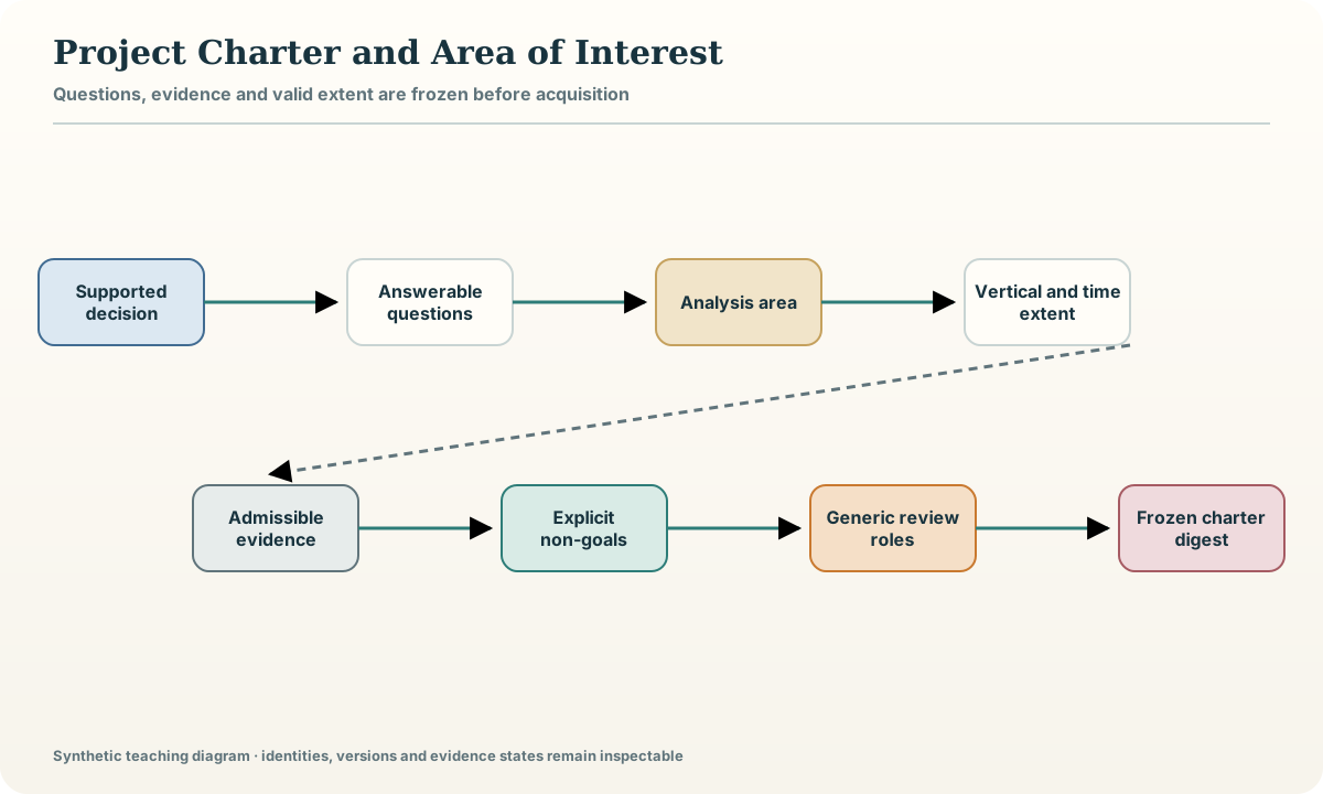
Begin with the decision the workbench is allowed to support, not with a list of available layers. A charter states the geological questions, intended readers, admissible evidence, spatial and temporal extent, resolution, update condition and release boundary. It also states non-goals. A workbench that compares regional hypotheses is not automatically fit for tenure advice, resource estimation, safety decisions or public reporting. Those uses require separate authority, evidence and review.
Represent the area of interest as a versioned geometry with an identifier, coordinate reference system, vertical domain and reason for selection. Keep display extent separate from evidence extent: a contextual map may extend beyond the area in which claims are valid. Record uncertainty at boundaries and the rule for including intersecting features. A charter change creates a new study version because it can alter source discovery, statistics and conclusions.
Record and evidence model
| Field or object | Operational meaning | |---|---| | charter_id | immutable identifier for the approved scope | | question_id | one answerable geological question | | aoi_geometry and crs_id | versioned horizontal boundary and reference system | | valid_z and valid_time | vertical and temporal validity | | non_goal and release_class | prohibited use and permitted audience |
Every record carries a version, validity interval, source or derivation link, quality state and review state. Missing, unknown, not applicable and failed are separate states; none is silently represented as zero or an empty string.
Controlled workflow
- Write one supported decision and three explicit non-decisions.
- Decompose the decision into answerable questions and evidence needs.
- Create and validate the AOI geometry, CRS and vertical domain.
- Declare scales, resolution limits, update triggers and users.
- Assign generic preparation, domain-review and release roles.
- Freeze the charter digest before source acquisition begins.
Record each step as an activity with declared inputs, parameters, outputs and checks. A rerun creates the same content or a documented difference; it never overwrites the evidence needed to explain the previous state.
Worked synthetic example
The synthetic study package SYN-WB defines a 24 km by 18 km rectangular analysis area in a declared projected CRS and a vertical domain from surface to 1.5 km below the synthetic datum. Its question is whether two alternative structural corridors deserve different evidence-gathering priorities. It explicitly excludes land-status advice, economic valuation, resource statements and operational decisions. A wider 10 km context buffer may be displayed, but claims are clipped to the approved analysis area.
The example is deliberately small enough to inspect row by row. Its names and numbers are fictional teaching values and cannot be used to infer a real place, right, resource, hazard or organisation.
Quality control and failure modes
Run six gates before accepting the lesson artefact: identity resolves the exact objects; spatial control confirms coordinate and extent validity; semantics preserve units, vocabularies and epistemic class; lineage exposes every transformation and dependency; quality records passed, failed and not-run checks; review binds a disposition to the exact content digest. A failed gate is retained as evidence and blocks only the affected use. It is never converted into a favourable value or hidden to simplify the display.
Common failure modes:
- Starting from attractive data rather than a decision
- Using the display extent as the validity extent
- Leaving non-goals implicit
- Changing the AOI without issuing a new version
- Assigning professional authority to the software or tutorial
Practical exercise
Complete the following tasks against a new copy of the synthetic package:
- Draft a charter for a synthetic geological question.
- Draw separate context, analysis and exclusion geometries.
- Define a change that would invalidate the frozen charter.
- Write a release statement that prevents scope expansion.
For every answer, cite the package object IDs, show the failed as well as passed checks, and state which conclusion would change if one assumption were reversed.
Completion artefact and verification
Deliver a signed-off synthetic project charter, AOI package and scope-change rule. Include a manifest, exact input identities, transformation or reasoning record, machine-readable validation results, human-readable limitations and the current review state. A second reader must be able to trace one accepted conclusion to its source support, one rejected path to its first failed gate and one unknown to the evidence required to resolve it. Rebuild the artefact from a clean location and compare content digests. Completion is withheld when a required source, parameter, permission or review is missing; no substitute data are invented.
Sources
- FAIR Guiding Principles, principles for findable, accessible, interoperable and reusable digital objects.
- Data Catalog Vocabulary version 3, a vocabulary for interoperable catalogues, datasets, distributions and data services.
- EPSG coordinate reference system registry, a maintained registry of coordinate reference systems, datums and transformations.