E4 · Publication Volume 26
Point Clouds
acquisition, attributes, classification, density and level of detail
Learning objectives
- Explain the decision and evidence boundary for acquisition, attributes, classification, density and level of detail.
- Select and implement the relevant representation or algorithm without hidden coordinate, support or topology assumptions.
- Separate exact predicates, approximation error, source uncertainty and visual delivery.
- Produce a point-cloud contract with density, classification and hierarchy diagnostics from synthetic evidence.
The lesson is complete only when the learner can defend the representation, transform, predicates, tests and release decision. A visually clean map or 3D scene without executable invariants and provenance remains unverified.
This is a general, institution-neutral tutorial with no relationship to any company or individual. All coordinates, geometries, grids, points, surfaces, volumes, attributes and review events in the lesson are synthetic and must not be used for an operational decision.
Decision context
The decision is whether a point cloud supports the intended measurement, classification, surface inference or visualisation at the required scale. A point is a sample with acquisition context, not a tiny surface element. The contract declares coordinate encoding, reference, scale and offset, acquisition method, return semantics where present, time, intensity or colour interpretation, classification vocabulary, withheld or invalid states, point support, density method and level-of-detail selection. Surface or volume claims require a separate derivation and assumptions.
Write the intended use, consequence of error, required evidence, spatial support and release authority before selecting a representation or transformation. Fitness is evaluated against a versioned contract and use, not attached permanently to a file extension.
Core concept
Point-cloud meaning lies in sampling pattern and attributes as well as coordinates. Density varies with range, view angle, occlusion, scan overlap and filtering. Classification is an interpretation attached to points and may have multiple versions. Integer coordinate storage often uses scale and offset to recover world coordinates; ignoring either changes geometry. Hierarchical organisation groups points by spatial nodes so a reader can request subsets or coarser levels, but lower detail is a selected sample and must not be described as the complete evidence.
Keep received evidence, accepted analytical views and derived representations as distinct objects. This allows corrected evidence, a changed transform or a new level of detail to generate a new result without rewriting history. Every coordinate and primitive therefore answers both a spatial question and a provenance question.
Algorithm and data model
Keep received point records immutable and store classifications, normal estimates, decimated levels and surfaces as derivatives. Decode coordinates with declared integer scale and offset before metric operations, preferably using a local computation origin. Organise large clouds in a hierarchy whose nodes record bounds, point count, spacing estimate and byte location. Selection rules should be deterministic for a fixed version. Filters state whether they remove noise, withheld points, duplicate returns or outliers and preserve a reason code for every exclusion.
Define parsing, semantic validation, canonicalisation, indexing, exact or approximate calculation, quality evaluation and encoding as separate stages. Each stage emits structured output and does not depend on interface state, file order, graphics-driver behaviour or undocumented defaults.
Constraints and invariants
| Invariant | Executable or review test | | --- | --- | | Coordinate scale, offset, reference and valid point states are explicit. | Reject or quarantine the exact affected object and preserve the received representation. | | Density is reported with spatial support and inclusion policy. | Evaluate this condition before creating a derived geometry, grid, surface or volume. | | Classification and decimation are versioned derivatives of received points. | Record the predicate, tolerance policy, observed values and coordinate frame. | | Random-access hierarchy reads reproduce the corresponding full dataset subset. | Make every repair a new version and rerun all dependent golden cases. |
An invariant must survive import, transformation, processing, export and rerun. A failed hard invariant produces no apparently valid substitute. Diagnostics remain visible with predicate, threshold, coordinate frame, scope and evidence, and require a reviewed rule before they can trigger repair.
Quantitative reasoning
Simple areal density is \rho_A=N/A, but it is meaningful only for a declared projection, footprint and inclusion rule. Three-dimensional density may use points per volume or nearest-neighbour distance, which answers a different question. Report point count by class and return state, quantisation step, bounds, density distribution by tile, nearest-neighbour quantiles, excluded counts, hierarchy depth and points delivered at each level. Test scale and offset round trips, duplicate coordinates with distinct attributes, empty nodes, highly anisotropic sampling, boundary points, classification changes and random-access reads that must match sequential decoding.
Every metric includes units, support, numerator and denominator where applicable, exclusions, comparison policy and evaluation version. Aggregate metrics are stratified when pooling can hide local geometry failure. A performance gain cannot overrule invalid topology, missing reference metadata or broken lineage.
Evidence and uncertainty
Keep acquisition uncertainty, interpretation uncertainty, discretisation error, numeric round-off and delivery error separate. Increasing coordinate digits or triangle count does not improve the original evidence. A sampled surface may be smooth and watertight while remaining poorly constrained between observations. Report uncertainty in the quantity and support to which it belongs.
Build an evidence packet containing immutable received objects, semantic declarations, validation findings, transform inputs and outputs, measured errors, test results, reviewer decisions and fingerprints. Contradictory evidence remains available. When a required reference, topology state or classification cannot be resolved, return unknown, conflict or blocked rather than inventing geometry.
Interfaces and storage
Interfaces transmit identity, coordinate reference, units, axis order, support, topology expectations, attribute association, null state, version and lineage beside coordinates. Structured errors identify the object, primitive, predicate, observed value, expected condition and rule. An interface that carries vertices but drops the transform or face orientation has not preserved the object.
Store authoritative received evidence separately from reproducible analytical derivatives and disposable delivery artefacts. Indexes, caches, pyramids and render meshes improve access but cannot become the only copy of source attributes or coordinate metadata. Round-trip tests verify identity, precision, topology, ordering, missingness and association after encoding changes.
Governance and review
Assign responsibilities to roles rather than named organisations or people: evidence custodian, representation author, algorithm maintainer, independent validator and release reviewer. A role may propose a repair but cannot erase the received geometry. Transform, predicate and tolerance changes are versioned and evaluated against fixed regression fixtures before release.
Exceptions are explicit decisions with scope, rationale, evidence, approving role, affected versions and review trigger. They never turn invalid topology into valid topology by label. The host website has no ownership or scientific-authority role in this workflow; it only delivers the tutorial.
Integration checkpoint
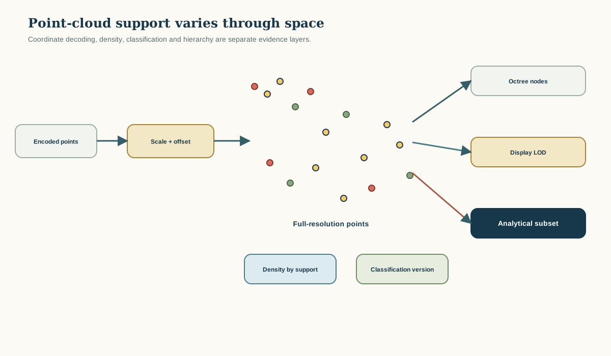
Read the figure as a reasoning map from preserved evidence through declared support and coordinates, controlled transformation, validation and scoped release. Each arrow represents a declared relationship. Integrate a point-cloud contract with density, classification and hierarchy diagnostics into SYN-SPATIAL, rerun earlier fixtures and record every changed assumption.
Synthetic worked example
Synthetic cloud SYN-PC01 contains a dense central strip, sparse margins and two scan passes with different synthetic intensities. A global density of 42 points per square metre hides cells below 2 and above 180. The controlled report maps density by fixed support, records return and class counts, and marks sparse cells as weak support rather than filling them. A hierarchy delivers a deterministic coarse view for display, while analytical neighbourhood calculations request full-resolution nodes and verify their decoded points against a sequential reference.
- Preserve the received object and state the intended decision without repair.
- Resolve identity, reference, units, support, topology and evidence eligibility.
- Run the versioned transform or predicate while retaining intermediate diagnostics.
- Issue accept, reject or quarantine and show how an independent reviewer reproduces it.
Practice task
Implement the chapter artefact against a synthetic fixture containing one normal case, one boundary case, one invalid case and one unresolved-evidence case. Preserve the received fixture. Produce canonical input, validation findings, derivative output, processing manifest, measured error and a short release decision.
Acceptance criteria:
- Every required identity, coordinate reference, unit, support and convention is explicit.
- The implementation is deterministic under stable ordering and the declared numerical policy.
- No repair overwrites received evidence or converts unknown into a guessed value.
- All hard failures block the affected derivative and remain machine-readable.
- A second implementation or reviewer can reproduce the result from the package alone.
Submit a point-cloud contract with density, classification and hierarchy diagnostics, golden and adversarial fixtures, exact findings, measured error and a limitations note. A screenshot is not sufficient evidence because it does not identify input versions, transforms, algorithms or rule configuration.
Common failure modes
- Reading integer point coordinates without applying scale and offset.
- Using one global density to claim uniform spatial support.
- Treating a point classification as an immutable observation.
- Running analytical neighbourhoods on a display level of detail without disclosure.
These failures share a pattern: implicit convenience is substituted for evidence. Diagnose the earliest boundary where the assumption entered, restore the source statement, make the transform or predicate explicit, rerun all dependent derivatives and supersede rather than overwrite the affected release.
Review questions
- Why is a point not a small surface patch?
- Which support must accompany a density estimate?
- How do scale and offset affect metric geometry?
- What must a hierarchical random-access test reproduce?
For every answer, identify the governing invariant, evidence needed to evaluate it, numerical or semantic policy involved and correct behaviour when the condition fails.
Sources and further reading
- ASPRS LAS 1.4 R15 specification, defining point records, scale and offset, classification, returns and coordinate encoding.
- COPC 1.0 specification, defining range-readable LAZ point data organised in a clustered octree.
- ISO 19107:2019 spatial schema, specifying conceptual geometry, topology and spatial operations for geographic information.
- ISO 19157-1:2023 geographic data quality, providing a framework for describing and evaluating geographic-data quality.