C5 · Publication Volume 15
Regolith, Vegetation and Human Effects
masking, false anomalies and mining disturbance
Learning goals
This lesson establishes that remote sensing observes the exposed and near-surface system, not an unobstructed bedrock map. The learner should be able to build a cover model; distinguish direct mineral response from indirect regolith, vegetation or morphology expression; design masks without erasing evidence; recognise moisture, burn, agriculture, roads and excavation as confounders; use negative controls; and plan field checks that test the surface process responsible for an anomaly.
Cover is not merely noise. Regolith records weathering, transport and deposition; vegetation can respond to substrate, water or disturbance; human modification creates its own spectral and geometric patterns. The correct interpretation identifies which surface process connects the measurement to the geological question.
Regolith architecture and transported cover
Residual regolith forms broadly in place but can be vertically differentiated by weathering, leaching, oxidation and duricrust formation. Colluvium, alluvium, aeolian sediment and other transported cover may move particles and geochemical or spectral signatures away from their source. Surface lag can concentrate resistant grains while concealing finer material.
Optical and thermal observations are dominated by the surface optical layer. A thin coating can control reflectance even when the underlying substrate differs. Remote mapping of a mineral at the surface may therefore identify weathering product, transported grain, precipitate or contaminant rather than primary bedrock.
Create a regolith-domain map before extrapolating spectral classes. Include landform, transport direction, surface age, erosion and deposition, drainage, soil moisture and exposure. Predictions should state whether the sought response is direct bedrock, residual weathering proxy, transported dispersion or geomorphic association.
Vegetation, biological crust and organic cover
Vegetation has strong spectral structure in visible, near-infrared and short-wave infrared regions. Species, canopy structure, water content, phenology, stress and shadow vary in space and time. Sparse vegetation can mix with soil; dense canopy can obscure mineral spectra almost completely. Biological soil crust and organic matter can alter surface colour and texture.
Vegetation may indirectly express substrate through nutrient, moisture, pH or rooting differences, but the relation is non-unique. Fire, grazing, drought, disease and land management can produce similar responses. A vegetation anomaly should be treated as an ecological observation until a causal chain to geology is independently tested.
Use seasonal observations and field cover estimates. Record fractional vegetation, canopy height where relevant, species or functional group, litter, biological crust and shadow. Do not apply one vegetation threshold across ecosystems, seasons and sensors without validation.
Moisture, atmosphere, illumination and surface state
Water absorbs strongly in several spectral intervals and changes scattering, darkness, thermal response and soil–mineral contrast. A rain event can make some absorptions appear deeper, conceal others and alter drainage patterns. Wet surfaces may be misclassified as dark material or shadow. Evaporative salts can create bright transient surfaces.
Terrain illumination, roughness and view direction interact with cover. Shadows reduce signal and ratios become unstable. Dust, smoke, haze and thin cloud alter spectra even when general quality masks consider the pixel clear. Surface state at acquisition is part of the observation.
Build a condition table for rainfall antecedent, season, solar geometry, cloud and aerosol quality, fire history and surface disturbance. Where data are unavailable, widen uncertainty or exclude a strong causal claim.
Human disturbance and infrastructure
Roads, roofs, waste, pits, embankments, drainage channels, cleared areas, agriculture and vehicle tracks can mimic lithological or alteration patterns. Fresh excavation exposes material that differs from surrounding weathered surfaces; it may reveal geology but also mixes fill, dust and transported rock. Straight edges, regular spacing and network association are useful but not decisive cues.
Human disturbance changes over time and can be detected by morphology, spectral mixture, night lighting or contextual maps. Treat a disturbed pixel as its own hypothesis rather than masking it automatically. Some decisions require excluding it; others require understanding whether it exposes or relocates material.
No named property or operator is needed for the method. Use synthetic disturbance classes and general infrastructure records. A site-specific interpretation must rely on authorised, current ground information and must not infer activity, ownership or compliance from imagery alone.
Masks, domains and negative controls
A mask declares where an analysis is not valid or where a competing surface dominates. Keep separate masks for cloud, shadow, snow, water, vegetation, saturation, low illumination, disturbance and poor atmosphere. A combined valid mask is convenient but loses diagnostic reason unless the component masks remain available.
Mask thresholds should be calibrated and sensitivity tested. Dilation around clouds may reduce contamination but also remove valid narrow features. A vegetation mask can erase geological response expressed through sparse canopy. Consider stratified models by cover domain rather than one universal classifier.
Negative controls include the same regolith landform away from the target, disturbed areas without predicted geology, different geology under similar vegetation, and stable surfaces across dates. They test specificity. A model that highlights every road, drainage line or wet patch has not isolated geological evidence.
Worked synthetic example
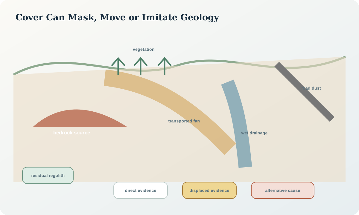
A synthetic short-wave infrared ratio anomaly follows a broad downslope fan. The strongest pixels occur in bare patches after a dry period; weaker values continue into sparse vegetation. Hypothesis A is transported alteration-related grains from an upslope source. Hypothesis B is a moisture and grain-size effect within the fan. Hypothesis C is dust from a nearby track.
The anomaly aligns with flow paths rather than bedrock structure. It weakens after rain, which supports surface-state sensitivity. A control fan with similar texture but no upslope source lacks the feature, while track dust produces a narrower linear response. Evidence favours transported material but does not establish its primary source or mineral identity. Field transects must sample upslope exposure, fan positions, control fan and track dust.
Interpretation and decision. Describe the surface domain and transport context with the spectral observation. Distinguish direct, indirect and displaced evidence. A target may remain useful for reconnaissance while location and material attribution stay uncertain. State where cover prevents a conclusion rather than interpolating through it.
Practice and audit checklist
Construct a synthetic scene with residual soil, transported fan, vegetation gradient, wet drainage, road and excavation. Create component masks, compare one global model with domain-stratified models, and test negative controls. Design a field transect that can separate source, transport, moisture and disturbance hypotheses.
Audit questions: What surface is actually observed? Is the signature residual or transported? Are vegetation and moisture dates known? Are masks retained separately? Was disturbance treated as an alternative? Do controls test specificity? Does the field plan sample mixtures and apparent negatives? Are gaps shown as unknown rather than filled geology?
Sources
- Spectral library materials and mixtures, includes soils, coatings, vegetation and human-made materials relevant to cover discrimination.
- Imaging spectroscopy applications and confounders, describes vegetation, soils, human materials, atmosphere and surface mixtures in one measurement framework.
- Surface-reflectance atmospheric compensation, explains why atmosphere-corrected comparison remains conditional on product quality.
- Known product artefacts, documents examples where resampling, emissivity inputs and misregistration create spatial artefacts.