B1 · Publication Volume 6
Coastal and Marine Environments
delta, shoreface, shelf, slope and deep-marine systems
Learning objectives
After this lesson, you should be able to compare river-, wave- and tide-influenced coasts, distinguish shelf, slope and deep-water processes, interpret shoreline migration from facies and surfaces, and separate water-depth inference from a simplistic offshore-fining rule.
Start with a field problem
Three cores along a basinward transect contain sandstone, heterolithic beds and mudstone. The landward core coarsens upward; the central core contains bidirectional structures and mud drapes; the basinward core contains graded sandstone beds in mud. Does the succession record delta progradation, a tide-dominated estuary, storm-driven shelf deposition, deep-water density flows, or several systems stacked through time?
Marine interpretation requires more than increasing water depth. Sediment supply, waves, tides, storms, currents, salinity, oxygenation, biological activity, shelf width and slope stability vary independently. The same point can move between environments as the shoreline migrates.
Core process model
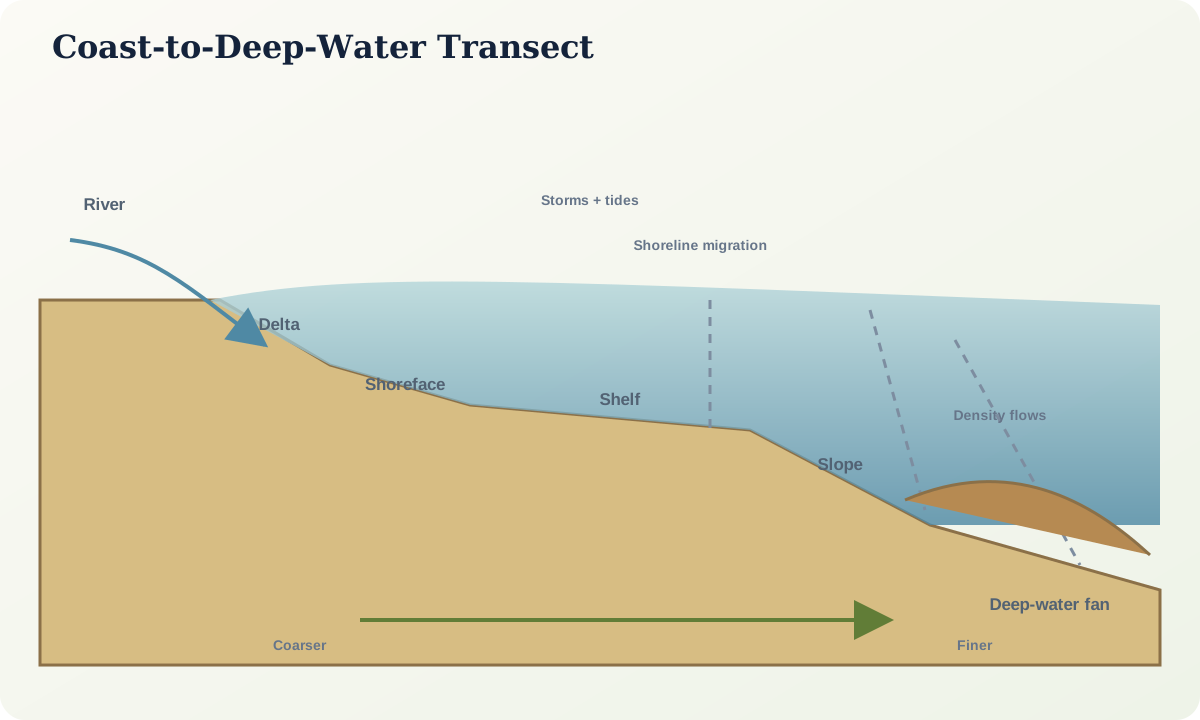
At a delta, a sediment-bearing river enters standing water and divides its load among channels, mouth bars, delta front and prodelta. Relative influence of river discharge, waves and tides affects geometry and reworking. No delta is governed by only one process at all times.
The shoreface is affected by breaking waves, currents and storms. Upper parts tend to experience frequent traction; lower parts may preserve event beds separated by bioturbated intervals. Barriers, tidal inlets, lagoons and estuaries add complex lateral changes. Mud drapes and bidirectional structures support tidal influence but are not exclusive without architectural context.
The shelf receives suspended fallout, storm-driven transport, contour currents and biological reworking. A storm can erode shallow sediment and deposit a graded or combined-flow bed farther offshore. The slope contains channels, gullies, mass-transport deposits and bypass zones. Deep-water systems receive turbidity currents, debris flows, hemipelagic settling and contour-current reworking. A graded sandstone does not by itself prove a submarine fan.
Evidence and measurement
Describe bed contacts, grading, lamination, hummocky or swaley geometry, wave and current ripples, mud drapes, bioturbation, fossils, trace assemblages, soft-sediment deformation and palaeoflow. In core, account for the cut surface and incomplete view. In logs, distinguish directly observed lithology from an interpreted electrofacies.
Map clinoforms, channels, lobes and erosional surfaces only at the resolution supported by data. A seismic reflector is a contrast surface, not automatically a time line or lithologic boundary. Well ties, velocity uncertainty, tuning and lateral facies change affect interpretation.
Water-depth indicators require calibration. Fossils and traces may constrain ecological conditions, but transport and reworking must be checked. Wave structures depend on wave climate and preservation. Offshore fining can be reversed by shelf-edge sources, contour currents or deep-water sand delivery.
Worked example
Suppose a vertical succession changes from offshore mud with sparse storm beds, to increasingly amalgamated sandstone, to cross-bedded sandstone with root traces. This is consistent with shallowing and shoreline progradation. Alternatives include local migration of a subaqueous bar, tectonic uplift, autocyclic channel switching or erosion that removed part of the record.
To test progradation, seek a basinward shift of coeval facies across multiple sections, systematic palaeoflow, regionally traceable flooding surfaces and age control. One coarsening-upward log is not enough. If the same surface overlies erosion landward but passes into condensed mud basinward, a relative shoreline shift becomes more defensible.
For the basinward graded beds, measure basal erosion, grain-size trend, sedimentary structures, bed compensation and lobe geometry. Density-flow deposition is plausible, but storm transport or slope failure from a nearby margin may compete.
Misinterpretations and uncertainty
“Marine” is not one facies. A fossil-bearing limestone, bioturbated mud, cross-bedded shoreface sand and deep-water turbidite can all be marine but reflect different processes and preservation. Conversely, tidal structures can occur in estuarine, deltaic and shelf settings.
Relative sea level is local: eustasy, subsidence, uplift, compaction and sediment loading all contribute. A landward facies shift can reflect reduced sediment supply without sea-level rise. A basinward shift can reflect increased supply without sea-level fall. Separate observation of trajectory from interpretation of cause.
Practical investigation
Build a coast-to-basin panel from three supplied logs. Define facies first, then draw no more than five correlation surfaces with confidence bands. Mark evidence for river, wave, tide, storm and density-flow processes. Produce one shoreline-migration model and one alternative driven mainly by sediment-supply redistribution.
Mastery check
- Why does a mud drape not uniquely identify a tidal environment?
- Name four processes that can move sediment across a shelf.
- What is the difference between a seismic reflector and a time surface?
- How can a coarsening-upward succession be tested regionally?
- Why must relative sea-level change be separated from shoreline trajectory?
Sources and further reading
- What is the continental margin?, National Ocean Service.
- Estuary geology, National Ocean Service.